LinksGlossaryMessagesSitemapHelp


Home

Policy Instruments

Select
Search
Filter
Encouraging public transport use through land use planning
SummaryFirst principles assesmentEvidence on performancePolicy contributionComplementary instrumentsReferences

Taxonomy and description
Definition
How can land use planning encourage the use of public transport?
Technology

Definition

Encouraging public transport use through land use planning involves the planning of new land development and the management of existing land in such a way as to:

  • improve conditions for the efficient operation of public transport, 
  • Improve the accessibility of urban areas and enable people to travel more by alternative modes;  and 
  • increase the demand for public transport, particularly by encouraging mode change from the private car. 

This instrument is now globally recognized as public transport- or transit-oriented development (TOD). It refers to compact, mixed-use, pedestrian and cycling friendly development that is ‘oriented’ to public transport and not just adjacent to rail and bus stations (UN HABITAT, 2013). By concentrating a mix of pedestrian- and cyclist-oriented development around public transport nodes, residents, visitors and workers are more likely to catch a train or a bus for out-of-neighbourhood trips, and walk or bike for shorter within-neighbourhood trips (Cervero et al, 2005). Public transport stops are a logical place to concentrate urban development. Of course, high-quality, well connected public transport service must exist to draw passengers to the station area in the first place, thus TOD relies on and implicitly assumes public transport is safe, reliable and time-competitive with the private car (UN HABITAT, 2013, citing Vuchic, 2007; Walker, 2011).

Renne (2009) defines specific factors required for true Transit-Oriented Development, so residents own fewer cars, drive less, rely more on alternative modes (walking, cycling, public transit, carsharing and taxi), and have a high level of local accessibility, as opposed to Transit Adjacent Development, which is conventional, automobile-oriented development located near transit stations (VTPI, 2013, citing Renne 2009).

Transit Oriented Development

Transit Adjacent Development

  • Grid street pattern
  • Higher densities   
  • Limited surface parking and efficient parking management
  • Pedestrian- and bicycle–oriented design
  • Mixed housing types, including multi-family
  • Horizontal (side-by-side) and vertical (within the same building) mixed use
  • Office and retail, particularly on main streets.
  • Suburban street pattern
  • Lower densities
  • Dominance of surface parking
  • Limited pedestrian and cycling access
  • Mainly single-family homes
  • Segregated land uses
  • Gas stations, car dealerships, drive-through stores and other automobile-focused land uses.

Table 1: Transit Oriented Versus Adjacent Development (VTPI, 2013, citing Renne 2009)

This instrument is closely related to the use of land use planning to reduce the need for personal motorised travel and public transport services.

How can land use planning encourage the use of public transport?

Several studies indicate that if development is planned specifically to encourage public transport there can be a significant reduction in per capita car travel. Public transport nodes, including rail stations, serve as a catalyst for more accessible land use by creating higher density, mixed-use, pedestrian- and cyclist-orientated centres. Households living in such neighbourhoods tend to own fewer cars, and people working in such areas are more likely to commute by alternative modes (partly because they do not need a car for lunchtime errands) (Cambridge Systematics, 1994). 

These factors result in higher levels of public transport commuting, increased non-motorised travel for non-commuting trips (such as shopping and trips to school), and reduced car travel. As a result of these various factors, there tends to be a "leverage" to much greater reductions in vehicle travel than that which is directly shifted from car to public transport. International research summarised by Newman and Kenworthy (1998, p. 87) indicates that each passenger-kilometre of rail travel appears to be associated with a reduction of 5 to 7 kilometres of car travel through these various mechanisms. 

Badoe and Miller (2000), in summarising the work of previous researchers, concluded that public transport service can facilitate land use development patterns, but is only one of many factors, and will not cause significant land use or travel behaviour change by itself. If an area is ready for development, improved transit service (such as a rail station) can provide a catalyst for higher density development and increased property values, but it will not by itself stop urban decline or change the character of a neighbourhood (VTPI, 2002).
In practical terms, this means that there are two specific but inter-related ways in which land use planning can encourage the use of public transport:

  • by locating trip origins and destinations near public transport routes or by ensuring that new developments are served by efficient PT service from their first day of use; 
  • by ensuring trip densities are sufficiently intense to establish an efficient service.

The general principle is thus to ensure that trip origins and destinations are arranged in nodal or linear patterns which are compatible with the demand patterns needed to ensure that public transport services, both bus and rail, are viable and efficient.
It is important to note that the effects of land use planning on public transport use are likely to be greatest where sufficiently strong regulation of land use is in place.
In its guide 'Shaping Up', the state government of Queensland (Government of Queensland, undated) offers guidance on the design of public-transport-friendly development, in the form of idealised 'how to do it' and 'how not to do it' examples, one set of which is shown below, for transport corridors in urban regions.

Regional transport corridorsregional transport corridors

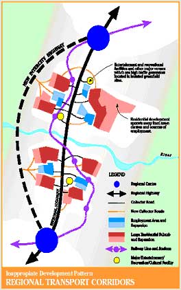
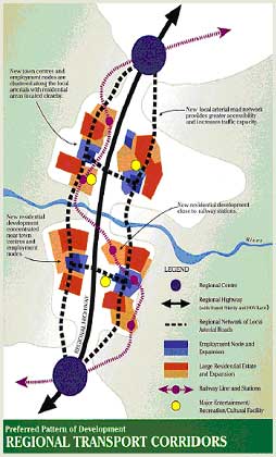
The Guide describes the principles involved in the design of transport corridors for improved public transport as follows:
"Urban growth often takes place along corridors created by major highways or railway lines. The way in which these transport corridors are planned and designed at the regional level can have major implications for public transport use. Corridor planning and the distribution of land uses also impacts significantly on public transport costs, operational efficiency and funding requirements".
The Guide suggests the following approaches to good practice: 

  • Public transport is more cost effective and efficient if organized along a linear corridor with highly accessible activity nodes, so development should be concentrated along major corridors based on a main 'line haul' public transport route (with feeder routes wherever appropriate).
  • Major activities, employment nodes and higher density residential areas should be encouraged near stations and significant stops and interchanges along public transport routes (preferably within 800 metres of a railway station).
  • Urban development should be compact, concentrated along public transport corridors, and focused on key business and activity nodes which incorporate public transport interchanges.
  • The overall road network should ensure that 90 per cent of the urban area is within 400 metres of public transport stops located on the arterial and collector road network. (This also supports faster public transport services and enables stops to be 250 metres apart).
  • A mix of business and residential land uses should be concentrated at clearly defined nodes located at the intersection of local arterials where 'line haul' public transport services converge. This concentrates trips at a discrete number of locations which allows multi-purpose trips and increases public transport passenger loadings.
  • Public transport interchanges should be integrated into these mixed-use business and activity nodes. This increases public transport use and enables easy and convenient passenger transfers between bus, rail and taxi services." 
    ('Shaping Up': Government of Queensland)

The UN Habitat report includes a diagram illustrating similar concepts, based on earlier work by Calthorpe (1993).

Figure 2

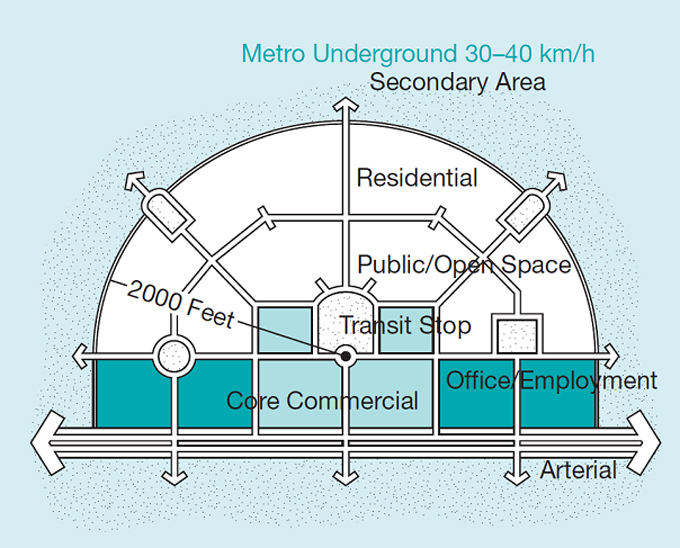
Neighbourhood-scale TOD site design, with mixed-use development within a walkshed (650 metres) of a public transport stop, with densities tapering with distance from the station (UN HABITAT, 2013, citing Calthorpe, 1993).

It should be noted that large scale park and ride facilities can conflict with accessibility and liveability benefits: a railway station that is surrounded by large parking areas and by main roads with heavy traffic is unlikely to provide the best environment for residential development or for pedestrian access. As part of land use planning, it is thus important that such facilities be properly located, designed and managed to minimise such conflicts.

Technology

Other than the rail and bus infrastructure and vehicles, this policy instrument is not dependent upon technology.


Top of the page


Text edited at the Institute for Transport Studies, University of Leeds, Leeds LS2 9JT