|
|
 |
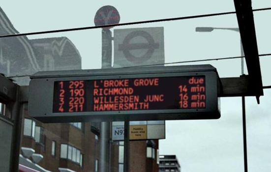
Real-time passenger informationTaxonomy and description TerminologyReal Time Passenger Information (RTPI) is a means of marketing public transport and providing electronic travel information to the users of public transport in “real time” via a range of sources, such as bus stops, stations, on vehicles and via the telephone or internet (Holdsworth et al, 2007). An example of the RTPI for the “Countdown” system implemented in London is shown in Figure 1. Many public transport agencies around the globe are considering or have already begun to provide real time information to the travelling public at large. Information provided via RTPI systems is usually concerned with the arrival and departure of the next public transport services, but other information, such as destinations, routes, fares and specific problems can also be provided.
TechnologyInformation provided in real-time has to be reliable, otherwise it will hinder or confuse users rather than aid their decision making. The technology has been developed over many years and can now be considered relatively stable. For services with dedicated rights of way (e.g. metro services), the technology calculates the predicted arrival times for the next vehicles based on the location of the vehicles within a signal “block”, the speed of the vehicles and the distance to the next station. Web surveys of major metro operators of the COMET1 and NOVA2 consortia of operators suggest that RTPI is already provided at most metro stations/interchange points and at metro stops (at least for the operators within the consortia). For road running public transport modes such as buses, a major difficulty is that they are constrained by other vehicles and pedestrians on the road. At the same time there have been advances in Automatic Vehicle Location (AVL) technology (Hickman, 1995) to enable tracking of bus locations (using sensors). Early variants (e.g. those operating in London) operate using beacon technology (Schweiger, 2003). An on-board unit receives signals from roadside beacons as the bus passes the beacon, and since each beacon has an unique identifier the location information is forwarded by radio link directly to a central system. The central system compares the scheduled arrival time with the current positioning and computes the “countdown” to arrival at the stop. This information is sent to the bus stop matrix displays (see Figure 1) which are equipped with a modem to receive the transmitted information. However, this tag and radio technology is considered dated and has been improved by on board Global Positioning Systems (GPS) based on satellite technology. By calculating data based on GPS satellites, a vehicle’s location (longitude and latitude) can be calculated to within 3 to 6 metres (Sun et al 2007). This can then be similarly transmitted to the electronic matrix displays available at stops/interchange points. Further details on advantages and disadvantages of the various implementations can be found in Horbury(1999). Whatever the technology deployed, all the traveller sees is the information available on the electronic displays (as shown in Figure 1). In addition, real time data can be sent to mobile phones and personal digital assistants (when users utilise a short messaging service (SMS or “text message”) to request the information), as well as displayed in the vehicle or via the Internet - see Figure 2.
1 COMET is the Community of Metros, a consortium dedicated to sharing best practice and a knowledge exchange cum benchmarking forum for the world’s largest metro operators. This group comprises metro operators as follows BVG (Berlin, Germany), LUL (London, UK), MOM (Moscow, Russia), MRTC (Hong Kong, China), MSP (Sao Paulo, Brazil) NYCT(New York, USA), RATP (Paris, France), STC (Mexico City, Mexico), TRTA (Tokyo, Japan). 2 NOVA is the sister organisation to COMET and serves a similar purpose of knowledge exchange, benchmarking and knowledge forum for metro operators that have a lower number of passengers per annum and comprises 15 members at time of writing (see http://www.nova-metros.org).
|