
This document responds to the first objective of the SMARTEST project : review of existing micro-simulation models. This corresponds to the Workpackage 2, review of tools, for which six different work areas have been identified, each addressed in one chapter.
Chapter 1 defines basic concepts such as "modelling", "users" and "inputs / outputs" to put the rest of the work into context. Chapter 2 covers the analysis of existing micro-simulation tools. The method used to collect model information was to send a written questionnaire to all known model designers. The objective of Chapter 3 is to identify user requirements for micro-simulation of traffic. Data has been collected through a questionnaire sent out to known users of micro- simulation models in the field of transport planning, especially those known to be developing and assessing transport telematics applications. Differences between what the micro-simulation model do and what the users want them to do are identified in Chapter 4. The objective of Chapter 5 is to identify the latest thinking in programming and modelling techniques. Finally, Chapter 6 reviews both current and likely future computing technology.
The users' questionnaire and the developers' questionnaire are reproduced respectively in Appendix A and Appendix B of this deliverable. Appendix C is the extended version of chapter 3; User Requirements, and gives more detailed information about the users' views. Appendix D is a summary of model designer answers and presents each model in about two pages. It also contains comparative charts for simulator features.
The CORD Project (CORD PROJECT, Deliverable No D004 - Part 3, Commission of the European Communities - R&D Programme Telematics Systems in the Area of Transport (DRIVE II), December 1994.) has maintained a co-ordinating role in the updating and compilation of a Transport Telematics Function list. Given the immense diversity of the field of Advanced Transport Telematics, the importance of this list cannot be overstated. The concept of area, seen mainly as a tool to structure the Functions list, has been proposed. Areas are sets of functions related by the nature of the services provided. They present complementary or alternative functions and sub-functions. The ten identified areas are:
From this functional point of view, users are defined as persons or organisations to whom functions are provided. Users can be:
In seeking interconnection and interoperability of information systems within the transport sector, the DATEX Project (DATEX, Traffic/Travel Data Dictionary, Version 3.0, Deliverable AC 23 - Part 3, Commission of the European Communities, RTD Transport Telematics Application Programme, December 1996.) proposed a Traffic/Travel Data Dictionary as an emerging standard for Traffic/Travel information exchange. This proposal followed an object-oriented approach.
A Traffic/Travel situation is defined as "a set of Traffic/Travel circumstances with a common cause that apply to a common set of locations". Traffic/Travel situations comprise of an event and status report, where a situation can be composed of situation elements. An element is defined as "a Traffic/Travel circumstance related to one data object and one location".
| object set | Instances |
|---|---|
| Traffic Data | average speed, concentration, flow, individual vehicle data, occupancy, travel time, origin-destination matrix |
| Traffic/Travel conditions | accident, delays/cancel actions, ferries/trains, incident, level of service, car parks |
| Ambient conditions | exhaust pollution, fog/smoke/dust, precipitation, weather data, wind |
| Road conditions | human activities, moving hazards, obstruction hazards, road maintenance, skid hazards, snow on the road |
| Traffic Management | action plans, service information, operator actions, traffic restrictions, re-routing, snow/ice equipment, traffic equipment status, traffic signal plan |
The Geographic Data Files standard (GEOGRAPHIC DATA FILES, European Community for Standardisation, CEN TC278, Version 3.0, October 1995.) has been developed to meet the needs of professionals and organisations involved in the creation, update, supply and application of referenced and structured road network data. It has been created to improve the efficiency of the capture, the production and handling of road related geographic information. This increase in efficiency is obtained by supplying a common reference model on which users can base their requirements and producers can base their product definition. The Feature catalogue provides a definition of real world objects that all relate to the road environment. The following feature themes are defined:
The next sections provide more details about the definitions of users, modelling and inputs/outputs. The model users and their needs are clearly identified. Functions actually offered, future trends in modelling, input data and outputs provided are better defined.
| Model | Organisation | Country |
|---|---|---|
| AIMSUN2 | Universitat Politècnica de Catalunya, Barcelona |  |
| ANATOLL | ISIS and Centre d'Etudes Techniques de l'Equipement |  |
| AUTOBAHN | Benz Consult - GmbH |  |
| CASIMIR | Institut National de Recherche sur les Transports et la Sécurité | |
| CORSIM | Federal Highway Administration |  |
| DRACULA | Institute for Transport Studies, University of Leeds |  |
| FLEXSYT II | Ministry of Transport |  |
| FREEVU | University of Waterloo, Department of Civil Engineering |  |
| FRESIM | Federal Highway Administration | |
| HUTSIM | Helsinki University of Technology |  |
| INTEGRATION | Queen's University, Transportation Research Group | |
| MELROSE | Mitsubishi Electric Corporation |  |
| MICROSIM | Centre of parallel computing (ZPR), University of Cologne | |
| MICSTRAN | National Research Institute of Police Science | |
| MITSIM | Massachusetts Institute of Technology | |
| MIXIC | Netherlands Organisation for Applied Scientific Research - TNO | |
| NEMIS | Mizar Automazione, Turin |  |
| NETSIM | Federal Highway Administration | |
| PADSIM | Nottingham Trent University - NTU | |
| PARAMICS | The Edinburgh Parallel Computing Centre and SIAS Ltd | |
| PHAROS | Institute for simulation and training | |
| PLANSIM-T | Centre of parallel computing (ZPR), University of Cologne | |
| SHIVA | Robotics Institute - CMU | |
| SIGSIM | University of Newcastle | |
| SIMDAC | ONERA - Centre d'Etudes et de Recherche de Toulouse | |
| SIMNET | Technical University Berlin | |
| SISTM | Transport Research Laboratory, Crowthorne | |
| SITRA-B+ | ONERA - Centre d'Etudes et de Recherche de Toulouse | |
| SITRAS | University of New South Wales, School of Civil Engineering |  |
| TRANSIMS | Los Alamos National Laboratory | |
| THOREAU | The MITRE Corporation | |
| VISSIM | PTV System Software and Consulting GMBH | |
Three types of organisations are mostly involved in the design of micro-simulation models. They are Research Institutes, Universities and Industrial organisations. The distinction between public and private institutes is difficult to appreciate because of the disparities that exist between countries. For example a university can be public or private depending on the country. Very few developers come from road administrations, city planning offices or traffic consultants.
| Country | Number of identified models | Number of analysed models |
|---|---|---|
| Australia | 3 | 1 |
| Canada | 2 | 2 |
| Finland | 1 | 1 |
| France | 5 | 4 |
| Germany | 9 | 5 |
| Italy | 2 | 1 |
| Japan | 4 | 2 |
| Netherlands | 3 | 2 |
| Spain | 1 | 1 |
| Sweden | 2 | 0 |
| UK | 11 | 5 |
| USA | 15 | 8 |
The distribution by country is given in alphabetic order in Table 2-2. We can see that micro- simulation models are developed in North America, Europe, Australia and Japan.
Micro-simulation models are essentially research products. Note that nine of them are commercial products (AIMSUN2, FLEXSYT II, FRESIM, HUTSIM, INTEGRATION, PARAMICS, THOREAU, TRAF-NETSIM and VISSIM) and are continuously in development. Three others can be obtained upon request (MIXIC, NEMIS and PHAROS with user agreement restricting use). Eleven are in development (AIMSUN2, ANATOLL, DRACULA, INTEGRATION, MELROSE, MITSIM, PLANSIM-T, SIGSIM, SISTM, SITRAS and VISSIM). Note that some model designers might have forgotten to indicate whether they had plans to enhance their models since question 6 of the questionnaire was just addressing the current state of model development.
| Urban | Motorway | Combined | Other | |
|---|---|---|---|---|
| CASIMIR | AUTOBAHN | AIMSUN2 | ANATOLL | |
| DRACULA | FREEVU | CORSIM | PHAROS | |
| HUTSIM | FRESIM | FLEXSYT II | SHIVA | |
| MICSTRAN | MIXIC | INTEGRATION | SIMDAC | |
| NEMIS | SISTM | MELROSE | ||
| NETSIM | MICROSIM | |||
| PADSIM | MITSIM | |||
| SIGSIM | PARAMICS | |||
| SIMNET | PLANSIM-T | |||
| SITRA-B+ | TRANSIMS | |||
| SITRAS | VISSIM | |||
| THOREAU |
Micro-simulation models can be classified according to the traffic conditions they can be applied to as given in Table 2-3.
The objective of micro-simulation models is essentially, from the model designers point of view, to quantify the benefits of Intelligent Transportation Systems (ITS), primarily Advanced Traveller Information Systems (ATIS) and Advanced Traffic Management Systems (ATMS). All models belonging to the urban, motorway and combined types address such objectives. Micro- simulation is used for evaluation prior to or in parallel with on-street operation. This covers many objectives such as the study of dynamic traffic control, incident management schemes, real-time route guidance strategies, adaptive intersection signal controls, ramp and mainline metering, toll plazas and lane control systems (lane use signs, electronic toll collection, high occupancy vehicle lane, etc.). Furthermore some models try to assess the impact and sensitivity of alternative design parameters (number of lanes, length of ramps, road curvatures and grades and lane change regulations). These objectives cover the functions identified in section 1 by the CORD Project. Note that this does not mean that all these models are designed to treat all these points. They all have different properties.
Models of the type "other" have been designed for highly specific objectives such as the modelling of the tactical level of driving and the testing of intelligent vehicle algorithms (in order to help people write Artificial Intelligence programs that drive vehicles in traffic), to provide a detailed roadway environment for a simulated robot driving vehicle, to evaluate the safety and comfort conditions of a line of cars on a single lane or to simulate strategies and to predict queues at toll booths. There are six models of this type and we consider that this number did not cause too much bias to the analysis of the micro-simulation models.
| Object / phenomenon | Modelled | Object / phenomenon | Modelled |
| Queue spill back | 87% | Parked vehicle | 35% |
| Weaving | 77% | Pedestrians | 26% |
| Incidents | 65% | Weather conditions | 26% |
| Commercial vehicle | 61% | Elaborate engine model | 19% |
| Roundabouts | 58% | Search for parking space | 13% |
| Public transports | 52% | Bicycles / motorbikes | 10% |
| Traffic calming measures | 42% |
Model designers made the following comments on objects and phenomena.
Queue spill back and weaving appear as the most modelled objects and phenomena. Search for a parking space, bicycles/motorbikes, elaborate engine model, pedestrians, weather conditions and parked vehicles are essentially not modelled. Other objects and phenomena are modelled by about one designer over two. Model designers seem to consider traffic conditions as essentially containing cars, commercial vehicles (for 2 out of 3 designers) and public transport vehicles (for half the designers) and not motorbikes, bicycles and pedestrians, traffic being insensible to weather conditions and under the consideration that drivers go from one point to another weaving across lanes and creating queues on roads and do not often park nor search for a parking space. Incidents may exist (for 2 out of 3 designers) and roads contain traffic calming measures for one designer out of two.
When the objective is traffic efficiency most of the models provide indicators to measure speed and travel time and to a lesser extent congestion, travel time variability and queue length. Indicators about public transport regularity and modal split are not often provided. Traffic efficiency from the designer point of view concerns one type of transport, typically by car, and does not concern other types. Note that two designers provide indicators to measure the number of stops and that two others provide indicators about the time spent stopped or creeping, the delay and the amount of acceleration.
Concerning traffic safety, half of the micro-simulation models provide indicators for headway but not for accidents, time to collision, interactions with pedestrians and overtaking, which were provided by about 2 designers out of 10.
The environment objective can be measured for half of the simulators by exhaust emissions. Roadside pollution level and noise level can be evaluated in a few models. Designers also consider technical performance objectives, but only fuel consumption rates as highly as exhaust emissions.
Comfort and Performance objectives are almost never considered.
| Objectives | Indicator | Provided |
| Efficiency | Speed | 87% |
| Travel time | 87% | |
| Congestion | 71% | |
| Travel time variability | 68% | |
| Queue length | 65% | |
| Public transport regularity | 26% | |
| Modal split | 16% | |
| Safety | Headway | 42% |
| Overtaking | 26% | |
| Number of accidents | 16% | |
| Accident / speed severity | 16% | |
| Time to collision | 16% | |
| Interactions with pedestrians | 16% | |
| Environment | Exhaust emissions | 52% |
| Roadside pollution level | 16% | |
| Noise level | 13% | |
| Comfort | Physical comfort | 3% |
| Stress | 0% | |
| Technical | Fuel consumption | 48% |
| Performance | Vehicle operating costs | 6% |
From the designer's point of view the aim of micro-simulation is to quantify the benefits of Intelligent Transportation Systems. They are measured essentially in terms of traffic efficiency with speed and travel time indicators. Obviously Intelligent Transportation Systems provide other benefits as well as traffic efficiency, such as those cited in our questions: safety, environment, performance, etc. but micro-simulation models currently appear to have some difficulties in producing indicators to assess objectives in these areas.
Telematics functions that are the most studied are vehicle detectors, adaptive traffic signals and co-ordinated traffic signals. Then follow some functions studied by about half of the models: ramp metering, static and dynamic route guidance and incident management. Regional traffic information, support for pedestrians and cyclists and public transport information are at the end of the list with very weak percentages.
These results probably reflect the evolution of traffic management measures. Firstly traffic signal control of intersections and ramps have been developed and simulated, then came route guidance systems. Vehicle detectors are modelled as they can provide data useful for the development of such systems. The results then show that 10 modelled functions are in the range 19%-42%, so it is difficult to see what will be the next telematics functions likely to be studied.
| Function | Studied | Function | Studied |
| Vehicle detectors | 77% | Variable message signs | 35% |
| Adaptive traffic signals | 74% | Adaptive cruise control | 32% |
| Co-ordinated traffic signals | 68% | Zone access control | 29% |
| Ramp metering | 58% | Automatic debiting and toll plazas | 29% |
| Static route guidance | 52% | Congestion pricing | 23% |
| Dynamic route guidance | 48% | Automated highway system | 19% |
| Incident management | 45% | Autonomous vehicles | 19% |
| Probe vehicles | 42% | Parking guidance | 16% |
| Priority to public transport vehicles | 42% | Regional traffic information | 10% |
| Motorway flow control | 39% | Support for pedestrians and cyclists | 10% |
| Public transport information | 6% |
Input is given to most of models by text files. These files describe the network configuration in terms of nodes, links, traffic signals, paths, vehicle arrival rates, link capacities, incidents, signal timing, etc. and specify general parameters of the simulation. Note that five models, AIMSUN2, MELROSE, PARAMICS, TRANSIMS and VISSIM have a network Computer Aided Design Graphical User Interface to input road network topology and geometry data. CORSIM and FREEVU provide tools to graphically create the input data files and FLEXSYT II has a user interface under development and testing to edit input.
Output is the simulation result. Most of micro-simulation models use a Graphical User Interface. It is generally an on-line animation with which user can visualise vehicle movements and state of traffic and signals, display various traffic variables and path information by clicking on objects (vehicles, links, etc.) and have an overview of traffic conditions by zooming capability and by, for example, colouring links according to density and velocity. Some models also provide diagrams, tables and time/space curves to analyse traffic conditions while others propose statistical results as text files. Note that the SITRAS model provides input and output files saved in popular database formats (dBase and Paradox).
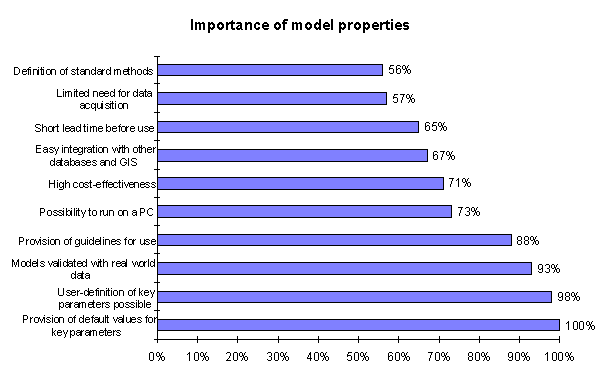
Most of the micro-simulation models provide sensible default values and the capability for user- defined changes to key parameters. In this sense they offer a certain adaptability to various traffic condition differences that may exist between countries, roads, vehicles, drivers, etc. One model designer in two considers that there is a limited need for data acquisition, though this point can be considered as a matter of opinion. Integration with other models and with other databases and Geographic Information Systems is not considered as easy. Finally four models over ten are approved by local authority/national transportation body.
Concerning hardware, models can run equally on UNIX systems and on PCs. Note that results add up to more than 100% since some models can run both on PCs and UNIX systems. One model, INTEGRATION, also provides versions for VAX and RS6000 computers and another, MICROSIM, is portable to many platforms (SUN, HP, SGI, LINUX, IBM-Risc).
| Model property | Available |
| Sensible default values for key parameters are provided | 94% |
| Key parameters can be user-defined | 97% |
| Limited need for data acquisition | 53% |
| Easy integration with other models | 41% |
| Easy integration with other databases and GIS | 31% |
| Approved by local authority/national transportation body | 41% |
| Will run on a low cost non specialist hardware | PC: 66%, UNIX: 53% |
Typical execution speeds of micro-simulation models are highly dependent of the network size and load and of the capabilities of the computer they are running on. Therefore the answers given should only be considered as very rough indicators of performance. Twelve designers quantified the execution speed to between 1 to 5 times faster than real time. Two models, MELROSE and DRACULA, have indicated to be respectively 14 and 20 times faster than real time, and two others between 6 and 10 times faster. The FREEVU model runs 50% slower than real-time. Twelve model designers did not answer this question.
Results are difficult to analyse because of the different interpretations that designers gave to these questions. Some answers described the general structure of the model: for example, network described by links, nodes, etc. with car-following model and lane-changing logic. Also what we would have considered as technical points were described by designers as innovative points: for example, some consider Object-Oriented programming or Graphical User Interface as innovation.
Nevertheless we can try to extract some trends from the answers.
From the designer's point of view, the objective is to quantify the benefits of Intelligent Transportation Systems primarily in Advanced Travellers Information Systems and Advanced Traffic Management Systems. The scale of application ranges from a small number of vehicles and intersections to a large number, about 200 nodes and many thousands of vehicles. Huge networks (300 nodes and 1 million of vehicles) can be considered by models that run on parallel architectures.
Model designers seem to consider traffic conditions as essentially containing cars that move from one point to another weaving across lanes and creating queues on roads. Incidents may exist and roads may contain traffic calming measures. Motorbikes, bicycles, pedestrians, public transports, weather conditions and parking phenomena receive little attention. The interest is essentially to estimate traffic efficiency in terms of speed and travel time and possibly considering congestion and queue length. In this context, functions mainly concern traffic signal control, route guidance and traffic condition estimation. Each model uses a different set of control strategies and algorithms.
Micro-simulation models provide a Graphical User Interface to visualise simulation results. It is generally animated and allows the evaluation of traffic conditions. Few models have a Graphical User Interface to input road network topology and geometry data.
Most of the models are adaptive in the way that key parameters can be user-defined. The integration with other models and with other databases is not considered as easy. One model over three is approved by local authority / national transportation body. Concerning hardware, a specialist architecture or system is not required, except for parallel models. The typical execution speed is between 1 to 5 five times faster than real time.
Validation and calibration have received various answers from model designers and most models are partially validated and calibrated. The identified limitations come essentially from an imperfect modelling of human behaviour and because modelling a network as real as possible is very difficult.
Concerning technical points, most of the models used a time slicing approach, in which computation is done at each time step, and most seemed to use Object-Oriented modelling and programming. Three of them followed an event-governed approach and four others used a parallel approach.
Section 3.2 describes general information about the users from whom we received answers. Section 3.3 gives the main areas of application for micro-simulation models. Section 3.4 describes the current use of such models. Finally, section 3.5 identifies in detail the user requirements in terms of scale of application, planning horizon, simulation objects, phenomena and objectives, transport telematics and functions, interface, time span and other model properties.
Half of the sample represents research organisations and another quarter road authorities (Question 2 in questionnaire). Some 14 percent of the respondents are private consultants and 9 percent are manufacturers. All categories are represented by at least 4-5 interviews.
| Type of organisation | Representation |
| Research organisations | 50% |
| Road authority | 27% |
| Consultant | 14% |
| Manufacturer | 9% |
| Country | No of respondents |
| France | 11 |
| USA | 7 |
| UK | 7 |
| Sweden | 7 |
| Norway | 2 |
| Australia | 2 |
| Finland | 2 |
| New Zealand | 1 |
| Italy | 1 |
| Holland | 1 |
| Denmark | 1 |
| Canada | 1 |
| Greece | 1 |
| Total number | 44 |
The sample of users that are included in the survey is not necessarily representative of the future model users. There is a clear geographical bias towards United States, United Kingdom, France and Sweden, and there is a clear bias towards research organisations.
A comparison can be made between the present use of models in general and desired future use of micro-simulation models (Questions 4 and 9 in questionnaire). It seems that there is some confusion between models in general and micro-simulation models.
| Application | present use of general models | future use of micro-simulation |
| On-line traffic management | 8 | 14 |
| Design and testing of control strategies | 37 | 37 |
| Evaluation of large scale schemes | 20 | 19 |
| Evaluation of product performance | 9 | 14 |
| Other applications | 13 | 10 |
As for the future use of micro simulation, the same percentage as above applies for testing of control strategies and evaluation of schemes. For on-line traffic management and evaluation of product performance, the use of micro simulation increases to 30%.
If all the respondents were equipped with proper micro-simulation models the overall pattern of applications would not change too dramatically. However, the most striking change would be a reduction in category "other" and a corresponding increase in the application of "evaluation of product performance" and in "on-line traffic management" applications, respectively.
One respondent answered: "It is a necessary tool if validated. It is an unreliable method if not validated. The aim of the model is essential as well as it's limitations."
Comments are more enlightening than the actual question. A good summary is probably that micro-simulation "is useful, but dangerous". Also, interesting comments are that "short time parking, very frequent marginal behaviour and pedestrian integration are difficult", and that "they are not suitable for large travel time and large distance networks".
The total number of answers (51) has been used for statistical analysis on this question.
Respondents also described their use of other types of models, such as assignment models EMME/2 [6 users]; CONTRAM [4 users]; TRIPS [3 users] and SATURN [2 users]; TRANSYT signal optimisation tool [3 users] and SIMRES macro model [2 users].
From the comments on advantages as well as disadvantages, it can be concluded that functionality, validation, graphical interface and integration with other software tools are emphasised. Size limitations are also mentioned as an important restriction in some cases.
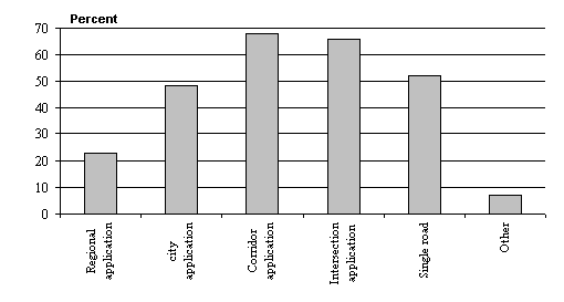
65% of the users say that they would use micro-simulation for corridor and intersection level
applications respectively. Using micro-simulation for city application attracts 50% of the users,
so does using it for single roads.
Regional traffic analysis is today only commonly carried out on a macroscopic scale with models such as EMME/2 or SATURN. But nevertheless, 23% of the respondents are interested in using micro-simulation for regional applications.
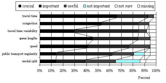
Efficiency
Among efficiency indicators travel time, congestion, travel time variability, queue lengths, speed and PT regularity all are very important. Only modal split has a figure below 50%. It is interesting to notice that congestion, travel time variability and queue lengths all have higher figures than vehicle speed. Among factors not listed, the number of stops is the most frequent answer.
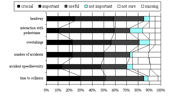
Safety
Safety indicators are also considered crucial / important to a large extent. Headway, interactions with pedestrians and amount of overtaking seem to be the most valuable indicators. Accident speed and number of accidents have lower figures. Time-to-collision seems to be of surprisingly low interest in spite of its strong relationship to conflicts and accidents. However, the comments reflect scepticism or uncertainty about how such indicators may be incorporated in micro- simulation models.
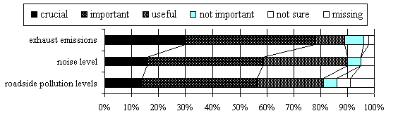
Environment
Exhaust emissions are the most interesting of the environmental indicators. Roadside pollution and noise levels have lower figures.
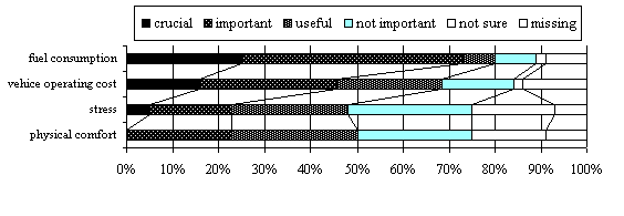
Comfort and technical performance
Fuel consumption is crucial to include as a measure of technical performance. Vehicle operating costs and physical comfort are of little interest.
| Adaptive traffic signals | 91% crucial or important |
| Co-ordinated traffic signals | 88% |
| Priority to public transport vehicles | 83% |
| Vehicle detectors | 81% |
| Ramp metering | 78% |
| Incident management | 74% |
| Variable message signs | 74% |
| Dynamic route guidance | 69% |
| Motorway flow control | 63% |
All other telematics or functions are considered crucial or important by less of 40% of users. Information systems, Automatic debiting, Cruise control and automated highway systems seem to be of less importance.
The required speed of micro-simulation models is faster than real time. About half (21) require an execution speed of over 5 times faster than real time, and another 14 are satisfied with a speed of 1 to 5 times faster than real time. Six have no definite opinion.
These results are confirmed in the ranking of the three most important properties that users were asked to give. Most important seems to be that the micro-simulation model should have been validated, but also that key parameters can be user defined and that the model will run on a low cost non specialist computer.
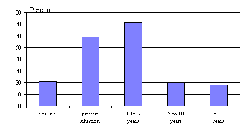
Users would like to be able to perform analysis of a variety of specific applications, including on- line applications, control strategies, large scale schemes and product performance tests. The scale of applications ranges from regional applications to single road cases, and the time horizon ranges from on-line to several years. The requested time span of the simulation is 5 minutes to 12 hours with an emphasis on the peak flow time periods.
There is then demand for: functionality which should include possibilities to model:
This is of course a tall order, and it is unlikely that all these requirements can be fulfilled within one single system. The questionnaire has nevertheless in many cases given clear indications concerning the relative importance of different factors, which may be helpful in future system development.
According to the questionnaire replies it is important that the most significant factors are taken into account and are based on validated field studies. The emphasis on validation is a reflection of the uncertainty concerning behavioural relationships. New knowledge about the effects of intelligent traffic systems will emerge continuously during many years to come. New functions that meet new demands will be developed. This indicates that the system should be as open as possible to changes in functional relationships. Driving behaviour that is concealed in the model system source codes and cannot be changed by anyone apart from the programmer is therefore not desired by the user and makes the system conservative and impractical. It must therefore be possible for the user to control the behavioural relationships that are used in the model and add new relationships based on newly acquired knowledge.
Gap identification is performed primarily by comparing the User Requirements (summarised in Chapter 3 and reported in detail in Appendix C) against the features of the 32 tools analysed (summarised in Chapter 2 and reported in more detail in Appendix D.
The gaps in the SMARTEST models (section 4.5) are identified by looking at the features and performance requirements considered most important by the users (scoring over 50% of the declared interest). Some suggestions on how to proceed towards model improvement specifications are provided in the conclusions (section 4.6).
On the developers' side, every developer can be considered as a user, only 9 of 28 organisations (32%) who answered the developers' questionnaire also answered the users' questionnaire.
These results indicate that there is a strong tendency for users and developers to belong to the same community and shows that there is a real need for model developers to disseminate their tools outside their own environment. Perhaps there is also a need to make the models more user- friendly so that they can be used by more than the people who developed them.
Concerning the type of networks users are interested in the modelling, corridor applications rank first (68%), then come intersection applications (66%), single road (52%) and city applications (48%). If we compare this with traffic conditions covered by the 32 models analysed, keeping only the 26 belonging to the "urban", "motorway" or "combined" categories, we notice that 46% of them are able to model urban traffic, 15% motorway traffic and 38% both. From this comparison, and taking into account other comments found in the questionnaires, we could deduce that there is a limited need for models only able to deal with motorway traffic and that micro-simulation models should evolve towards combined models. Another important point, which seems to be a real gap, is the identified need for single road modelling, including two-way rural roads and overtaking modelling.
But some important aspects must be underlined: firstly the evaluation of many ATT applications, (a fundamental objective for micro-simulation) requires large scale micro-simulations. Secondly, model accuracy is not so crucial for system performance measurement by large scale simulation as in the case of intersection and corridor applications. Finally, in order to face the problems related to the computation time large scale simulation can be suitably limited to meaningful city subareas.
Models provided by designers can easily accommodate the number of nodes and of vehicles that corridor and intersection applications require (if highly specific models are excepted). In some cases, with parallel architecture or with increasing computing power, models can also be applied to city and regional applications.
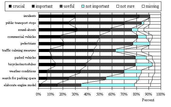
Great interest in including incident and Public Transport in micro-simulation is also confirmed by the analysis of model designer answers. In fact, 65% of the analysed micro-simulators include an incident model and 52% include a Public Transport model.
Roundabouts and commercial vehicles' behaviour are also important for building a coherent traffic model, so they are provided respectively by 58% and 61% of the micro-simulators.
A clear gap is the lack of pedestrians (26%) and bicycles/motorbikes (10%) models, which are not present in many of the state of the art micro-simulators.
It should be noted that queue spill back and weaving are commonly modelled traffic phenomena.
Among efficiency indicators, travel time, congestion, travel time variability, queue length, speed and Public Transport regularity, are considered very important by users.
Most of the models provide indicators to measure speed and travel time. Congestion, queue length and travel time variability indicators are also provided in many models whereas indicators about Public Transport and modal split are not often provided.
Safety
Safety indicators are considered crucial/important to a large extent. Headway, interaction with pedestrians and number of overtaking result as the most valuable indicators.
Concerning traffic safety, 42% of micro-simulation models provide indicators for headway but not for accidents, time to collision, interaction with pedestrians and overtaking (provided by about two designers over ten).
Environment
According to the user requirement analysis exhaust emissions are the most important environmental indicator, whereas noise level and roadside pollution seem not so interesting.
About 50% of the analysed models measure effects on the environment by exhaust emission indicators. Few models provide indicators for roadside pollution and noise level evaluation.
Comfort and technical performance
According to users fuel consumption is the most important indicator to be evaluated by models in order to estimate traffic technical performance. Physical comfort and vehicle operating costs would be not so interesting.
In state of the art models, comfort and performance objectives are almost never considered.
One designer over two uses the fuel consumption indicator to measure the technical performance.
Conclusion
From user requirement analysis, it seems that micro-simulation models would be used mainly for evaluation of efficiency and technical performance (that is fuel consumption) and emissions. Safety and comfort indicators seem less interesting.
From the designer point of view, the aim of micro-simulation is to quantify the benefits of Intelligent Transport Systems. Benefits are measured essentially in terms of traffic efficiency (speed and travel time indicators).
Obviously there is an increasing users' interest to obtain other benefits from Intelligent Transport Systems, like those stated above: safety, environment, performance, etc.
Model designers therefore have to improve the set of the existing modelled indicators so that the micro-simulator users' expectations are delivered.
Urban Traffic Control is the main application for micro-simulation. All other telematics or technological functions are considered crucial or important by less than 40% of users.
From the designer's point of view, the telematics/technological features that are mostly considered are vehicle detectors, adaptive traffic signals and co-ordinated traffic signals. Static and dynamic route guidance, ramp metering and probe vehicles are functions modelled by about 50% of the models.
Micro-simulation model designers distinguish the input part of interface (simulation configuration, including network description) from the output one (simulation result).
Input for most of the models is provided by text files (describing the network configuration). Only five models support a Computer Aided Design Graphical User Interface to input road network topology and geometry data (AIMSUN2, MELROSE, PARAMICS, TRANSIMS and VISSIM).
Other implemented solutions provide a menu-driven environment that helps the user create the input data files (FREEVU) and tools to graphically create the input data files (CORSIM and FREEVU).
Output is the result of simulation. Most of simulation models use Graphical User Interface (generally on-line animation by which users can visualise vehicle movements and traffic signals state, display various traffic variables and path information, provide an overview of traffic conditions through zooming capability and other graphical features).
Some models provide diagrams, tables and time/space curves to help analyse traffic conditions while others propose statistical results by text files.
The users clearly appreciate the benefits of a user friendly interface for network building and presentation of results. Few models have a network builder and interfaces with analysis packages and Geographical Information Systems could be improved.
Concerning hardware, models can run equally on UNIX and on PC therefore a low cost non specialist computer is satisfactory.
This situation points out a considerable gap. The models require better calibration and validation and their interfaces should provide the user with tools to help them perform this task. This requires better simulation output analysis tools, statistical tools, and GUI facilities for experimental design.
Tables 4.1 to 4.4 give the modelling capabilities of the four micro-simulation models considered in the SMARTEST project, for the following fundamental features:
In these tables, only features considered as crucial or important by at least 50% of users are considered.
| AIMSUN2 | DRACULA | NEMIS | SITRA-B+ | |
| Incidents | Yes | Yes | Yes | Yes |
| Public Transport | Yes | Yes | Yes | Yes |
| Roundabouts | Yes | Yes | Yes | No |
| Commercial Vehicles | No | Yes | Yes | Yes |
| Pedestrians | No | No | No | No |
Table 4-2: indicators
| AIMSUN2 | DRACULA | NEMIS | SITRA-B+ | |
| Travel time | Yes | Yes | Yes | Yes |
| Congestion | Yes | No | Yes | Yes |
| Travel time variability | No | Yes | Yes | Yes |
| Queue length | Yes | No | Yes | Yes |
| Speed | Yes | No | Yes | Yes |
| Public Transport regularity | No | No | Yes | Yes |
| AIMSUN2 | DRACULA | NEMIS | SITRA-B+ | |
| Headway | No | No | Yes | No |
| Interaction with pedestrians | No | No | No | No |
| Overtaking | No | No | Yes | No |
| Number of accidents | No | No | No | No |
| Accident speed severity | No | No | No | No |
| Time to collision | No | No | No | No |
| AIMSUN2 | DRACULA | NEMIS | SITRA-B+ | |
| Exhaust emissions | Yes | Yes | Yes | No |
| Noise level | No | No | No | No |
| Roadside pollution level | No | No | No | No |
| AIMSUN2 | DRACULA | NEMIS | SITRA-B+ | |
| Fuel consumption | Yes | Yes | Yes | No |
| AIMSUN2 | DRACULA | NEMIS | SITRA-B+ | |
| Adaptive Traffic signals | Yes | Yes | Yes | Yes |
| Co-ordinated Traffic signals | Yes | Yes | Yes | Yes |
| Priority to Public Transport vehicles | No | Yes | Yes | Yes |
| Vehicles Detectors | Yes | Yes | Yes | Yes |
| Ramp Metering | Yes | No | No | No |
| Variable Message signs | Yes | No | Yes | No |
| Incident Management | Yes | No | Yes | Yes |
| Dynamic Route Guidance | Yes | No | Yes | Yes |
| Motorway Flow Control | No | No | No | No |
| Congestion Pricing | No | Yes | No | No |
| AIMSUN2 | DRACULA | NEMIS | SITRA-B+ | |
| Key parameters user defined | Yes | Yes | Yes | Yes |
| Default parameter values provided | Yes | Yes | Yes | No |
| Good Documentation | Yes | Not yet | Yes | Yes |
| AIMSUN2 | AIMSUN2 was used in a pilot study of traffic management schemes on an environmental cell of the city of Dublin, measured flows and speeds were used as calibration variables. The Center for Transportation Studies of the University of Minnesota used AIMSUN2 in a simulation study of the I-494 freeway in Minneapolis, again AIMSUN2 was validated and calibrated against the flow and speed values provided by the detectors on the freeway. A large AIMSUN2 hybrid model of urban freeways and service roads consisting of the Barcelona's Ring Roads and main accesses to the city has been validated and calibrated using the observed flows and speeds. Quite recently the Dutch company DHV, users of AIMSUN2 have conducted several simulation studies in some Dutch cities (Maastrich, The Hague, Eindhoven, etc.) in which accurate calibrations of the models have been conducted against real-world data. Also the Saudi consultant company Beeah of Riyadh has used calibrated models of AIMSUN2 in its analysis of the transportation conditions during the pilgrimage to Mecca. |
| DRACULA | It has been tested on a number of SATURN networks and some travel performance such as delays and speed are compared with those from the calibrated SATURN models. Further calibration is expected to be carried out in the next few months in two projects involving traffic management measures for kerb guided bus and park & ride schemes. |
| NEMIS | It has been used to test strategies in five European cities (Turin, Alessandria, Salerno, Gothenburg and Leeds). The data required for calibration is the following: travel times on routes, queue lengths at the end of red stages, flows. The accuracy of the model has been demonstrated by the results of field trials in Turin, Salerno and Gothenburg |
| SITRA-B+ | Car-following rule partially validated (travel times were checked on an 8 intersection axis. Calibrated on a Lyon sub-network (LLAMD project). Some checking / validation of parameters / behaviours can be achieved through the visualisation interface facilities |
| AIMSUN2 | Graphical interface, windows based, to edit and input networks and to manage situations, experiments and view results (animation is also provided). |
| DRACULA | Input files are plain text, but SATURN input files can be used. Output is a combination of text files and an animated screen display of the simulation |
| NEMIS | Text files are used for loading the network data and setting the O/D, assignment and vehicle parameters. Text files are produced as output of the simulation. Currently an interface is being tested using Microstation graphics and showing queue clearance at junctions over a detailed plan of the actual urban network. |
| SITRA-B+ | Data inputs and results analysis: ASCII files. On-line visualisation: graphic display of the network and of the moving vehicles with the possibility to interrupt the run and to access to vehicles, links, detectors parameters. |
The tables presented in the previous section 4.5 and those included in the Appendix D show that gaps exist at both the modelling and performance levels. The main problems relate to modelling of applications of Advanced Transport Telematics systems for which large scale simulations are frequently required.
The SMARTEST models are in a good position even if improvements are required for all of them. The tables presented in paragraph 4.5 are a first step towards the specification of what to do in order to improve these models. The next step will concern the quantification of the efforts needed to cover the gaps and the clear statement of the developers' interest in improving the models along the suggested directions.
From the point of view of the project it is important to identify meaningful improvements that can be implemented and demonstrated during the life cycle of the project itself. According to this consideration, developments that can help improve more models at the same time and/or that can be performed through the collaboration of more Partners in the Project are recommended. Porting of interesting features from some models to other models where they are missing is a further possibility.
As far as these possibilities are considered, the following tables provide some interesting input. It summarises the point of view of the users on the advantages and disadvantages of the SMARTEST models (the complete list for all the models is provided in Appendix C):
| Model | Advantage |
| AIMSUN2 |
|
| DRACULA |
|
| NEMIS |
|
| SITRA B+ |
|
| Model | Disadvantage |
| AIMSUN2 |
|
| DRACULA |
|
| NEMIS |
|
| SITRA B+ |
|
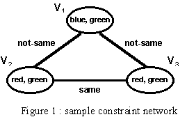
A solution to a CSP problem consists of an assignment of a value to each variable, within the variable's domain, satisfying all the constraints binding the variable. If we restrict the problems to binary or unary constraints, a CSP is often depicted as a constraint graph (constraint network), in which each node represents a variable and each arc represents a constraint between the variables, being these the end points of the arc. The figure 1 below, shows an example of a simple constraint network where three variables, V1, V2 and V3 may assume values in the domain [red, green, blue] and are interconnected by logical constraints such as "not-same" or "same".
Constraint systems are solved by constraint satisfaction algorithms, which correspond to search
procedures working on the constraint system (constraint graph) looking for compatible
assignments to the set of variables. Several methods are available, but all tend to fall within three
basic categories : Generate and Test, Backtracking and Consistency Techniques (Constraint
Propagation). It should be
also noted that some form of CP is rather often assumed as a basic implementation technique in
Qualitative Modelling approaches (see, ahead, the section "Modelling Technique: Qualitative
Modelling" ).
Application to Traffic Modelling
In the area of traffic and transport applications, a number of problems have been investigated, from an operational research point of view, which may be described in terms of constrained optimisation: optimisation of traffic control parameters such as traffic signal timings, resource allocation and scheduling (e.g. rostering and formation of driver and vehicle shifts), route search and planning, etc. Concerning traffic modelling, few attempts have been made in using CP techniques to model traffic flow behaviour at intersection and network level. This was usually done using CP as a tool to implement qualitative models of the traffic network (see ahead, the section "Modelling Technique: Qualitative Modelling" ). The prototype KITS system (KITS, 1996) and the one developed by NTT Data Co. (Sugimoto et al., 1992) are two examples.
The theory of fuzzy logic is based on the concept of "fuzzy set". Given a universe of element S, a fuzzy set F of S is a mapping from the elements of S to the interval [0,1]. The value 0 is used to represent complete non-membership, the value 1 complete membership, and values between 0 and 1 represents intermediate degrees of membership. If the set S represents the universe of the discourse, for example the set of "people", it is possible to define the fuzzy subset "tall" with a mapping from the heights of the element of S to the interval {0,1}. The mapping is usually called membership function (it computes the degree of membership to the set "tall" of a given element of S) and the set "tall" a linguistic variable (Zadeh, 1965) (see figure 2 (a)).
Fuzzy logic has been quite successfully applied to several industrial processes for different purposes, including control, information retrieval and management, pattern recognition and decision support. Fuzzy (knowledge-based) systems and fuzzy controllers are two main classes of application; they can be applied to complex processes, when mathematical models are difficult to devise, and in cases where the control system may be specified on the basis of "expert knowledge". Such kind of systems operate almost in the same way: (1) the output values of the system to be controlled are first fuzzyfied, then (2) a set of fuzzy inference rules is applied to decide how to react to fuzzyfied input values and how to act on output variables, (3) these output values are finally defuzzyfied and applied as an input to the controlled system (see figure 2 (b)).
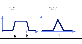
Figure 2 (a) representations of a linguistic variable

Figure 2 (b) basic structure of fuzzy systems
Application to Traffic Modelling
While application of fuzzy logic to traffic control and management tasks has been reported by several authors application to traffic modelling in itself is a relatively unexplored topic. Here, developments seem possible in two main areas: enhanced modelling of driver and flow behaviour, interpretation of model information and data.
As for the first aspect, recent work has shown that fuzzy simulation can capture the inexact specification of behaviour of single drivers controlling the vehicle. This has been investigated, for instance, in the TRANSIMS project at the Los Alamos National Laboratory (Davis, 1994). The advantage of exploiting a fuzzy model, is that fuzzy concept like "visibility", "weather conditions", "asphalt conditions" may be included to model driver behaviour in the form of fuzzy inference rules. Also, this approach could be followed to enhance conventional, mathematical- based car-following models by including fuzziness and approximation in the parameters used to model driving decisions (e.g. distance from the preceding vehicles, turning decisions, route choice, etc.).
Besides, fuzzy logic can be applied as a model to analyse and interpret traffic data and information (see, e.g., ENTERPRICE, 1996). Handling the usual traffic parameters (such as level of service, queue length, etc.) as linguistic variables (e.g., "free flow", "congested flow", "long queue", etc.) it is possible to provide traffic operators with a view of the traffic conditions which are closer to his/her understanding of the traffic behaviour than purely numerical and threshold-based representations.
Three main categories of qualitative modelling methods are known: component-based, process- based and constraint-based. The differences among them lie in the focus of the modelling approach (for instance, explanation of the behaviour of a system through the behaviour of its components - component-based approach - vs. description in terms of processes - process-based approach) All of them, however, allow generating and analysing representations of the behaviour of a system in a space of possible states (envisioning) and to use such representations for, e.g., prediction or diagnosis purposes.
Research in this area has resulted, so far, in development of both theories, including analysis of their mathematical and computational background, and practical programming and application tools. Qualitative simulation tools represent the most interesting outcome from QM, the QSIM package being the best known of them (Shults, 1996). Applications have been tried and developed in different technical and scientific domains, including analysis of electrical circuits, analysis and design of VLSI systems, analysis and evaluation of structural design, hazard identification in chemical plants, steam engines and plants, to cite a few of them. An updated view of the topics addressed and research carried out in the area of qualitative modelling can be obtained from WWW resources such as the QR home page at the Nara Institute of Science and Technology, Japan (http://ai-www.aist-nara.ac.jp/doc/qphysics/) and the home page of the MONET project, the European Community Network of Excellence on qualitative systems and reasoning (http://www.aber.ac.uk/~dcswww/MONET/).
Application to Traffic Modelling
Qualitative modelling methods have been applied to traffic modelling, mostly with the aim of achieving qualitative simulation of a traffic flow network to be used for decision support in network management. Known applications address mainly motorway simulation and, to a smaller extent, urban simulation. All of them provide a macro-simulation approach and no applications are known, so far, addressing the micro-simulation level.
The work of Cuena (1988) represents the first attempt in this area. The AURA system includes a qualitative simulation of traffic flows in urban motorways with the purpose of analysing near to congestion situations. Martin et al. (1994) have implemented a qualitative simulation model of an urban traffic network to be used to support decisions in an urban traffic control system. Other approaches are presented in (Sugimoto et al., 1992) and (Sauthier and Faltings, 1992).
ES/KB systems have a number of interesting and distinguishing features, when compared with more conventional software programs:
Application to Traffic Modelling
The combination of ES/KBS capabilities with that of simulation models has received much interest in various application areas including, for instance, industrial process control, manufacturing and finance. In general, the use of ES/KBS in combination with traffic modelling can be beneficial to the enhancement of the environment where the simulation model is used. For instance, an ES/KBS can be used for supporting the user of the simulation model during the task of setting up a simulation. The support provided by the ES/KBS may range from advising on set up of parameters to the more complex task of assisting in building up scenarios to be simulated or translating high level specifications of simulation experiments into executable simulations. Likewise, ES/KBS could be used for helping interpretation of simulation results and of the large amount of data and information which are usually obtained by traffic models. Both aspects could be of course combined, leading to ES/KBS capabilities embedded in the overall simulation environment helping the user as intelligent front- and back-end to the simulation model.
Different types of virtual reality exist, differentiated by the extent to which emerging technologies are incorporated. Bubley (1994) provides the following distinction between them.
Application to Traffic Modelling
The primary advantage of virtual reality is that it is capable of recreating complete, real-life scenarios, rather than 2-D planar representations. Integration of virtual reality and micro- simulation models would improve the visual interface between the computing system and the user. It would become possible to represent, simulate and provide the desired output for traffic environments in true 3-D fashion (Figure 3). The graphical representation would no longer be limited to a simplified and overhead view, but rather can be viewed from all angles. Given an immersive VR system, users would be able to "step into" the traffic environment and participate in and experience first hand the simulation and its results.
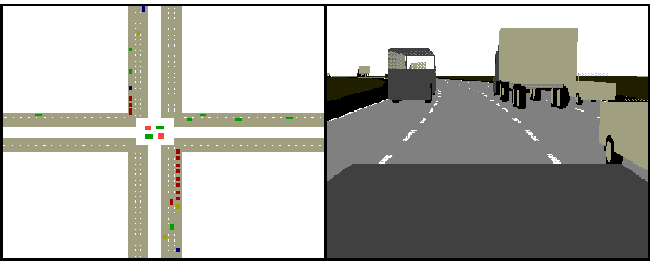
Figure 3: Traditional simulation vs. virtual reality based simulation
Indirectly, virtual reality can be applied to micro-simulation through the investigation of vehicle- driver interfaces. Through simulation, dynamic driver profiles and behaviours can be developed and subsequently implemented in traffic models.
Traditionally, many different techniques have been employed to model the various facets of the transportation industry (e.g. modelling of traffic impacts, travel demand, vehicle pollution and emissions, and effects of transport policies). The results from these are more often than not incompatible, thus the need for a single encompassing method of data integration and display (Sutton, 1996). GISs are becoming more widely used and their boundaries expanded in attempts to fulfil the above. They have the "potential to serve as the long-sought transportation data and systems integrator - to serve as a basis for the organisation of information and the design of information systems" (Vonderohe et al, 1993, p.49).
Application to Traffic Modelling
The long-term mission of a GIS is to provide a uniform graphics environment in which to integrate the data for numerous purposes. Results should be displayed such that they can be easily compared to other spatial data within a single GIS environment. For example, vehicle and transit volumes can be compared with accident counts or air quality indexes (Sutton, 1996). This can be accomplished with an expanded spatial database that consists not only of links and nodes, but also zones. In addition to physical attributes (geometric, number of lanes, intersections), traffic attributes (speed, volume, accidents) and travel attributes (trip ends, mode, routes), operational attributes (traffic signals, traffic signs, pavement markings, detours) can also be included. Figure 4 illustrates various attributes of a network link typically stored in a GIS.
In the short-term, GISs can be linked to transportation models using specialised software and/or hardware packages. These integrate the GIS attribute files to the network files of transportation models and organise the data in attempts to overcome the limitations and capabilities of each. Examples of linkages include ARC/INFO to TRANPLAN and ARC/INFO to EMME/2. Although both of these transportation models are macroscopic representations rather than microscopic, it illustrates that such linkages are feasible.
Figure 4: GIS network and link attributes
Alternatively, GISs can simply be used in conjunction with transportation models. Abdel-Aty et al (1997) combined Maptitude with TRANPLAN (macro-simulation) in determining route selection. GIS generated routes were based on static conditions whereas planning models provided networks using dynamic conditions (e.g. travel time and traffic volume). Route selections from each method were compared and a preferred routed, based on study criteria, was chosen.
A GIS has also been implemented in a modal emissions model where it capitalises on travel demand, simulation and statistical models combined with new activity and emissions relationships to provide improved mobile source emissions estimates (Georgia Tech, 1997). The benefits of integration of a GIS environment, fuel consumption, pollutant emission and dispersion models with traffic models (assignment, micro-simulation) has been also demonstrated by the EU project SLAM (SAVE Programme; Ambrosino et al., 1996).
Although some current traffic micro-simulation models are also capable of providing vehicle emission estimates, the strength of GISs lies in their abilities to manipulate, group in layer, aggregate and import/export the spatial data.
Vonderohe et al (1993) discuss a number of similar scenarios in which GISs were beneficial. An early application used GIS software for network editing and displaying of traffic assignment results derived from conventional travel demand software. In another, detailed land use information within GIS was used to generate trips under alternative development scenarios, the results from which were then used with traditional demand models.
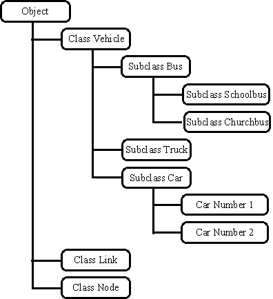
Figure 5: Hierarchical inheritance (Source: Rodriguez-Moscoso
et al, 1989, p.186)
Unlike the structured, procedural methods and computer languages, the object oriented approach focuses on the objects upon which the actions take place, rather than the actions themselves (University of Dundee, undated). The first stage is to determine what classes are to be used and what properties and actions are to be associated with each. Each action then becomes a separate module in the object oriented approach. Before proceeding any further, a few definitions are in order. A class acts as a template to define the behaviour of all variables of a certain type (Boote, 1995; Stefik & Bobrow, 1986). It is a collection of attributes (properties and actions) which describes an entity (University of Dundee, undated). Classes relate to each other through inheritance, the sharing of structures or behaviours defined in one or more other classes through an hierarchical structure (Booch, 1991) and through links which model the inter-relationships between object classes (Figure 5). An object is the variable within the class. It can otherwise be known as an instance when one wants to emphasise that an object is being referred to rather than the class of the object (Boote, 1995).
Application to Traffic Modelling
Rodriguez-Moscoso et al (1989, p.178) state that implementations of traffic simulation models "lack an explicit representation of the assumptions made about the work." As a result, "they have increasingly become more difficult to understand and to read as more changes are added or new modifications are made." Their solution is object oriented programming which will allow for a more explicit and understandable representation of a vehicle's properties and behaviours. In addition, the authors point out that the reusability of programming will decrease software development times considerably.
Booch (1991) discusses the application of an object oriented approach to developing a traffic management system for a large rail network. Functions of the system include train routing, systems monitoring, traffic planning, location tracking, traffic monitoring, collision avoidance, failure prediction and maintenance logging. These requirements suggest four sub-problems to solve: networking, database, human/machine interface and real-time analogue device control. This is somewhat comparable to a vehicular network in which each vehicle is equipped with advanced communication technology (e.g. route guidance, vehicle sensors, etc.). The network is composed of communication between the vehicles and dispatch centres. The database is composed of data from individual vehicles: their location, planned routes, speeds, etc. The human/machine interface exists between the driver and vehicle and facilitates interaction between the two. Lastly, a number of sensors and actuators must be incorporated into the system (e.g. vehicle presence detectors, actuated traffic signals, etc.). Object characteristics determined from the sub-problems include vehicles, roadway (links and node) and plans. Each vehicle has a location on the roadway and has one active plan (Booch, 1991). The remainder of Booch's application to railway management focuses on the design, evolution and modification of a software package and hence is not considered here.
Horiguchi et al (1996, 1994) describe the development of AVENUE, a micro-simulation model based on a hybrid block density method to model traffic flow, driver's route choice and lane choice behaviours, based on object oriented programming. The latter provides a high degree of flexibility in describing and modifying the traffic model (Horiguchi et al, 1994). Three of the principle classes defined will be discussed. The first class is base-node which is further subdivided to yield sub-classes OD-node and intersection-node. The second is base-link and is combined with base-node to provide the network. Attributes of base-link include length, number of lanes, capacity, route guidance (i.e. travel costs), etc. Base-vehicle, including passenger car, bus and truck sub-classes, is the third class. Object attributes in this class include origin, destination, route choice method and other things. Input required for AVENUE simulation is road network data, signal control parameters and origin-destination travel demand patterns (Horiguchi et al, 1994).
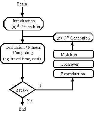
Figure 6: Genetic algorithm structure
The most common genetic operators are reproduction, crossover and mutation (Foy et al, 1992). Reproduction chooses potential solutions from the population, based on their fitness evaluations, that will be used to create new generations. The high fitness characteristics are to be passed on whereas the low fitness are to be discarded. The second operator, crossover, randomly selects two solutions from the population and crosses them at a random position within the population to form two new offspring (e.g. two solutions 111111 and 000000 can be combined after the third position to yield new solutions 111000 and 000111). The crossover probability, defined by the user, controls the frequency with which this operator is applied: too high and good solutions can be bypassed, too low and the procedure can stagnate (Hadi & Wallace, 1993). Mutation, the third operator, randomly alters the composition of the individual populations to assure variability in the population (e.g. a 0 would be changed to a 1 or conversely). Again, the probability with which a population is altered is defined by the user: a high probability will essentially result in a random population development (Hadi & Wallace, 1993).
Further advances in the field of genetic algorithms have been reported by Xiong and Schneider (1992) and more recently by Sadek et al (1997). Xiong and Schneider modified the reproduction operator such that new generations are developed not only from the best solutions from the generation just past, but also the best solutions from all previous generations. Their subsequent solutions are superior to results obtained from the original genetic algorithm as discussed above, for the reason that not all of the good properties were being passed from one generation to the next. In addition, the good properties that did survive were found to have disappeared after a number of generations. Sadek et al revised the manner in which solutions were represented and operated on within the GA structure. "It has become more apparent that real-world problems cannot be handled with binary representation and binary operators" (Sadek et al, 1997, p.8). They envisioned a more appropriate data structure (e.g. floating point and real-value vector representations) and special genetic operators which were subsequently adopted into their study. They concluded that their approach was promising in terms of both solution quality and coding complexity. A more detailed description of this approach is contained in their respective paper.
Application to Traffic Modelling
Recent research has reported the application of Genetic Algorithms in the following transportation contexts:
Generally speaking, Genetic Algorithms can be used in place of more traditional optimisation techniques. Sadek et al (1997) compared the performance of their Genetic Algorithm to that of a non-linear programming software package. Not only was the algorithm able to handle larger problems, it also produced comparable results in less than a third of the time.
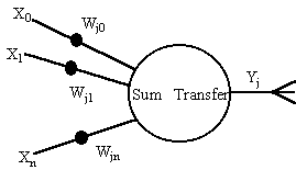
Figure 7: A neuron
Neural Networks is a broad term covering a great many different architectures or paradigms. The operation of these paradigms can vary enormously. However, all neural networks share some basic common features. They are composed of a number of very simple processing elements, known as neurons. These elements take data in from a number of sources and compute an output dependent in some way on the values of the inputs, using an internal "transfer function". The neurons are joined together by weighted connections; data flows along these connections and are scaled during transmission according to the values of the weights (Figure 7). The output of a particular neuron may therefore contribute to the input received by another. Naturally such a system is of little use unless it communicates with the outside world and so some connections take data in from an external source, whilst others pass data back out. The neural network's functionality is very much bound up in the values of the connection weights, which can be updated over time, causing the neural network to adapt and possibly "learn". Partly because this idea is so abstract, those working with neural networks have tended to impose a more rigid structure in practice. Several simplifications are made:
Figure 8: A typical feed-forward neural network
Neural networks can be categorised according to the type of learning rule employed. Three main learning schemes have been devised; supervised (Hecht-Nielson, 1989), reinforcement (Kohonen et al, 1988; Hopfield, 1982) and self-organising (Kohonen, 1988; Grossberg, 1976). A fourth category of neural networks can be defined as those networks which use more than one type of learning; these are often described as hybrid networks (Leonard et al, 1992).
Application to Traffic Modelling
Neural networks are of particular use as a tool to model systems which are not well understood or to represent relationships which are difficult to express logically or mathematically. This makes them well suited to modelling many aspects of transport because transport systems are often highly non- linear. In addition, the sheer complexity of many traffic scenarios (where many autonomous agents are interacting) can make it very difficult to reach a clear understanding by observation alone. The semi-automatic nature of neural networks can help reveal relationships which were previously obscured. Areas of particular focus within transport are modelling driver behaviour, analysis of the complex space-time relationships of congested traffic, traffic control and image processing.
There are two approaches to use parallel computing architectures (Hanebutte & Tentner, 1995). The first is to write new simulation software that includes algorithms for use with parallel processors, the second is to adapt an existing proven simulation model to function in a parallel framework. For obvious reasons, the latter is the simplest of the two and should be given due consideration. In either case, the data and/or simulation model must be divided and assigned to allocated processors. This allows larger networks to be simulated as the model's size restrictions apply only to the networks within the sub-divisions rather than the cumulative network.
Application to Traffic Modelling
Parallel computing can be applied to traffic modelling as a way of improving performance of computationally expensive procedures, including traffic assignment over large networks and the simulation process itself. The all-or-nothing assignment technique was optimised by van Grol and Bakker (1991). Each parallel processor was responsible for independently calculating a single shortest path. Improvements to simulation speed were of the order n, where n represents the number of shortest path trees and hence the number of processors.
AIMSUN2 and TRAF-NETSIM, both micro-simulation models (the first of which is included in the SMARTEST project), have been developed for parallel computing architectures (Barceló et al, 1996; Hanebutte & Tentner, 1995). Both used geographic decomposition such that the status of vehicles located within each individual region was updated in parallel. In limited testing (network consisting of 561 sections and 428 junctions), the parallel version of AIMSUN2 operating on a SUN SPARC station with 4 processors had an execution time 3.5 times faster than its sequential counterpart (5 minutes vs. 17 minutes) and approached real-time operations. Similarly, TRAF-NETSIM operating on an IBM SPx parallel system of 4 processors with a network of 400 intersections (1280 nodes and 3200 links) required 219 seconds (3.65 minutes) to complete a 10 minute simulation.
A third parallel microscopic simulation model is Paramics (Duncan, 1996). On a single workstation, it is capable of modelling a network containing up to 3500 vehicles in real-time, using a 0.5 second time-step; larger networks, containing more vehicles, can be modelled with the parallel multi-processor version (Duncan, undated).
Traditionally, traffic simulation programs have used fixed time intervals for scheduling schemes. At the conclusion of each interval, the position of all vehicles is known and their respective positions for the subsequent interval is calculated. Event based simulation takes a different approach and can achieve improved performance levels for traffic simulation problems. The components of the model consist of events which are activated at certain points in time. Objects in the simulation (e.g. vehicles and traffic signals) maintain their current state and change status only at the occurrence of an event. For example, a traffic signal turning red constitutes an event. Given this, the status of a vehicle approaching the light will change from running condition to stop condition. A subsequent event, changing of the light to green, will once again invoke the running condition (Hotta et al, 1995). Other events include, but are not limited to, a vehicle:
The fundamental dilemma that parallel event based simulation must address is that cause-and- effect relationships in the physical system become sequencing constraints in the simulator (Fujimoto, 1990). Can one event be executed concurrently with another without knowing the effects that they may have on each other? Fujimoto explains that the sequencing constraints dictate the order in which events are executed relative to one another. This becomes increasingly complex and data-dependent, unlike the parallelisation of fixed interval simulation. Without additional information, the only event that can be safely processed is that with the smallest time- stamp, leading inevitably to sequential rather than parallel execution.
Application to Traffic Modelling
Parallel execution of discrete event simulation can be used to reduce the required processing time by using the advantages of parallel computing (previously discussed) and event simulation. Rather than update the position of vehicles at fixed time intervals, their behaviour is only simulated while they are moving, otherwise nothing happens. In large simulated networks in which there are vast number of events (e.g. networks containing many local streets interrupted by traffic signals), the benefits to such a system may not be as substantial. The number of intervals and associated updates in a fixed time schedule should be compared to the number of events requiring simulation in order to approximate the benefits to implementing a parallel discrete event design.
STEER, a dynamic micro-simulation model (Clegg & Ghali, 1995) uses a parallel event based design to evaluate the implementation of various traffic management strategies. "The benefits in speed of execution and simplicity of modification to code are considerable with this design" (Clegg & Ghali, 1995, p.2). However, the simulation is quite simple in that car following, lane changing and acceleration logic are not considered. The authors provide no additional information on how this is overcame or how it affects the validity of the model's outcome.
Parallel discrete event simulation is not a panacea. Duncan (1996, p.63) suggests that fixed time operation is "crucial to success in congested traffic networks - vehicular movement can be approximated using fluid flow techniques as long as the traffic is free-flowing, but this is seldom the case these days." The non-deterministic variations in traffic flows that can result in severe congestion can only be modelled with a time-slice simulation such as Paramics (discussed previously), not an event driven one (Duncan, 1996).
Knowledge discovery in databases is the non-trivial process of identifying valid, novel, potentially useful, and ultimately understandable patterns in data.
Although commonly used in reference to KDD, the term data mining is considered as only one step of many in the KDD process (Fayyad, 1997; Brachman & Anand, 1996; Fayyad et al, 1996). Data mining refers to the application of algorithms to enumerate patterns from, or fit models to, the data (Fayyad et al, 1996). These algorithms are vast in numbers and are often based on concepts from machine learning, pattern recognition and statistics, including case-based reasoning, classification and non-linear regression, decision-tree induction, genetic algorithms, graphical models and neural networks (Brachman & Anand, 1996; Fayyad et al, 1996).
KDD and particularly data mining, have also been implemented in parallel database management systems. This has resulted in the ability to process more data, build and solve a wider range of models and achieve a greater level of accuracy with each (Small & Edelstein, undated; Holsheimer et al, 1996).
Two additional primary steps in the KDD process, as identified by Brachman and Anand (1996) include model development and output generation (these respectively precede and follow the data mining step). Model development includes segmenting the data, choosing an analysis model which best represents the data (e.g. regression, decision-trees, neural networks, etc.) and selecting the parameters that will be focused on. Output generation is supported by a variety of presentation and data transformation tools and can result in simple statistical measures, textual descriptions, graphical representations of relationships and action descriptions. More complex aspects of the KDD process are described by Brachman and Anand (1996) and Fayyad et al (1996). Challenges to be met by KDD deal with databases that are increasing in size and dimension, time varying, and missing data or containing noisy data. In addition, improvements must be made in the areas of user interface and integration with other systems (e.g. database management systems, spreadsheets, etc.). These deficiencies are further explained in Fayyad (1997) and Fayyad et al (1996).
Application to Traffic Modelling
Currently, the need for knowledge discovery in a traffic modelling context is not substantial as the traffic data collected does not surpass the processing abilities of the users and models. However, in a future traffic environment in which intelligent vehicles, automated roadways, roadside instrumentation and communication, and dynamic route guidance systems are prevalent, the need may become more apparent. There will be new opportunities to continually collect vast amounts of data on drivers' behaviours and characteristics, travel demands, vehicle locations and attributes, and network information in addition to the traffic data currently recorded, predominantly volume, occupancy and speed. The use of KDD systems will allow for the identification of underlying patterns and relationships between data variables that might otherwise go undetected. Ideally, these would lead to improvements in the management, calibration, interpretation and validation of the traffic modelling software systems.
Ambrosino, G., Timms, P., Turrini, M., Romanazzo, M., Valenti, G. (1996) Evaluation Methodology for Energy Impacts of Traffic Network Based on Urban TT Services: the SLAM Project in Florence, Proc. of the 3rd World Congress on Intelligent Transport Systems, October 1996, Orlando, Florida
Barceló, J., Ferrer, J.L., García, D., Florian, M. & Le Saux, E. (1996) The Parallelization of AIMSUN2 Microscopic Simulator for ITS Applications. The 3rd Annual World Congress on Intelligent Transport Systems, Florida, USA.
Booch, G. (1991) Object Oriented Design with Applications. The Benjamin/Cummings Publishing Company, Inc., California, USA.
Boote, J. (1995) Introduction to HLU Concepts I. NCAR Graphics User Conference, Colorado, USA - http://ngwww.ucar.edu/conf4.0/HLUconcepts1/025.html.
Brachman, R.J. & Anand, T. (1996) The Process of Knowledge Discovery in Databases. Advances in Knowledge Discovery and Data Mining, Fayyad et al (eds.) MIT Press, London, England, pp.37- 58.
Brule', J.F. (1992) Fuzzy Systems - A Tutorial, http://www.csu.edu.au/complex_systems/fuzzy.html
Bubley, D. (1994) Virtual Reality: Video Game or Business Tool. Financial Times Management Report, Financial Times Business Information, London, England.
Clegg, R. & Ghali, M. (1995) Road Network Simulator (RONETS) - Introduction to STEER1 v2.0. York Network Control Group, University of York. Unpublished.
Cuena, J. (1988) The Qualitative Modelling of Axis-Based Flow Systems: Methodology and Examples. In Proc. of European Conference on Artificial Intelligence 1988, Munchen
DeKleer, J., Brown, J.S., (1984) A Qualitative Physics based on Confluences, Artificial Intelligence Journal (24), pp 7-83,
Duncan, G. (1996) Simulation at the Microscopic Level. Traffic Technology International, Feb/Mar, pp.62-66.
Duncan, G. (Undated) Paramics Traffic Simulation Ltd. http://www.paramics.com/
ENTERPRICE (1996) The ENTERPRICE Project - Functional Specification, Tech Rep. Softeco Sismat
Fayyad, U.M. (1997) Editorial. Data Mining and Knowledge Discovery - An International Journal, Kluwer Academic Publishers, Vol.1, No.1 - http://info.gte.com/~kdd/index.html.
Fayyad, U., Piatetsky-Shapiro, G. & Smyth, P. (1996) From Data Mining to Knowledge Discovery: An Overview. Advances in Knowledge Discovery and Data Mining, Fayyad et al (eds.) MIT Press, London, England, pp.1-36.
Forbus, K., (1984) Qualitative Process Theory, Artificial Intelligence Journal (24), pp 85-168,
Foy, M.D., Benekohal, R.F. & Goldberg, D.E. (1992) Signal Timing Determination Using Genetic Algorithms. Transportation Research Record 1365, National Research Council, Washington DC, pp.108-115.
Fujimoto, R.M. (1990) Parallel Discrete Event Simulation. Communications of the ACM, Vol.33, No.10, pp.31-53.
Georgia Tech. (1997) Overview of the GIS-Based Mobile Emissions Model. Poster Session at Transportation Research Board 76th Annual Meeting, Washington DC.
Grossberg, S. (1976) Adaptive Pattern Recognition and Universal Recording: (1) Parallel Development and Coding of Neural Feature Detectors. Biological Cybernetics Vol.23, pp.121- 134.
Hadi, M.A. & Wallace, C.E. (1993) Hybrid Genetic Algorithm To Optimize Signal Phasing and Timing. Transportation Research Record 1421, National Research Council, Washington DC.
Hanebutte, U.R. & Tentner, A.M. (1995) Traffic Simulations on Parallel Computers Using Domain Decomposition Techniques. The 2nd World Congress on Intelligent Transport Systems, Yokohama, Japan.
Hecht-Nielson, R. (1990) Neurocomputing. Addison-Wesley, Reading MA.
Holsheimer, M., Kersten, M.L. & Siebes, A.P.J.M. (1996) Data Surveyor: Searching the Nuggets in Parallel. Advances in Knowledge Discovery and Data Mining, Fayyad et al (eds.) MIT Press, London, England, pp.447-470.
Hopfield, J.J. (1982) Neural Networks and Physical Systems with Emergent Collective Computational Abilities. Proceedings National Academy of Sciences Vol.79, pp.2554-2558.
Horiguchi, R., Kuwahara, M., Katakura, M., Akahane, H. & Ozaki, H. (1996) A Network Simulation Model for Impact Studies of Traffic Management "AVENUE Ver.2". The 3rd Annual World Congress on Intelligent Transport Systems, Florida, USA.
Horiguchi, R., Katakura, M., Akahane, H. & Kuwahara, M. (1994) A Development of a Traffic Simulator for Urban Road Networks: AVENUE. 1994 Vehicle Navigation and Information Systems Conference Proceedings, Yokohama, Japan, pp.245-250.
Hotta, M., Yokota, T., Nagai T. & Inoue, T. (1995) Congestion Analysis and Evaluation by Traffic Simulation. The 2nd World Congress on Intelligent Transport Systems, Yokohama, Japan.
Junchaya, T., Chang, G-L. & Santiago, A. (1992) Advanced Traffic Management System: Real-Time Network Traffic Simulation Methodology with Massively Parallel Computing Architecture. Transportation Research Record 1358, National Research Council, Washington DC, pp.13-21.
KITS (1996) DRIVE II R&D Programme, DRIVE Project V2039, Deliverable No. 13, Final Assessment of Applications; Tested Methodologies and Models.
Kohonen, T. (1988) Self Organization and Associative Memory, Second Edition. Springer-Verlag, New York.
Kohonen, T. et al (1988) Statistical Pattern Recognition with Neural Networks: Benchmark Studies. Proceedings of Second Annual IEEE Conference on Neural Networks.
Kuipers, B., (1984) Commonsense reasoning about causality: deriving behaviour from structure, Artificial Intelligence Journal (24),
Kumar, V. (1992) Algorithms for Constraint Satisfaction Problems : A Survey, AI Magazine, 13
Leonard, J.A., Kramer, M.A. & Unger, L.H. (1992) Using Radial Basis Functions to Approximate a Function and its Error Bounds. IEEE Transactions on Neural Networks Vol.3 no.4, pp.624-626.
Lin, Y-B. & Fishwick, P.A. (1995) Asynchronous Parallel Discrete Event Simulation. IEEE Transactions on Systems, Man and Cybernetics.
Martin, G., Toledo, F., Moreno, S. (1994) Qualitative Simulation of Traffic Flows for Urban Traffic Control. Artificial Intelligence Applications to Traffic Engineering, Bielli, M., Ambrosino, G., Boero, M. (Eds), VSP, Utrecht, The Netherlands
OECD (1990) 1st OECD Workshop on Knowledge-Based Expert Systems in Transportation, Jamsaa H. (Ed.), VTT, Espoo, Finland
OECD (1992) 2nd OECD Workshop on Knowledge-Based Expert Systems in Transportation: Operational Experiences and Prespectives, Transport Canada, Montreal, Canada
Rodriguez-Moscoso, J.J., Chin, S-M., Santiago, A. & Roland, R. (1989) Object-Oriented Programming in Traffic Simulation. Traffic Control Methods. Proceedings of the 5th Engineering Foundation Conference, California, USA, pp.177-190.
Sadek, A.W., Smith, B.L. & Demetsky, M.J. (1997) Dynamic Traffic Assignment: A Genetic Algorithms Approach. Presented at Transportation Research Board 76th Annual Meeting, Washington DC.
Sauthier, E., Faltings, B. (1992) Model-Based Traffic Control. Proc. of the Int. Conf. on Artificial Intelligence Applications in Transportation Engineering, San Buenaventura, Ca, USA, pp 133-152
Shults, B. (1996) Toward a reformalization of QSIM. University of Texas Artificial Intelligence Laboratory TR AI96-245,
Small, R.D. & Edelstein, H.A. (Undated) Scalable Data Mining. Two Crows Corporation - http://www.twocrows.com.
Stefik, M. & Bobrow, D. (1986) Object-Oriented Programming: Themes and Variations. AI Magazine Vol.26, pp.40-62.
Sugimoto, T., Nonaka, S. & Oohama, H. (1992) Traffic Prediction and Qualitative Reasoning. Proc. of the Int. Conf. on Artificial Intelligence Applications in Transportation Engineering, San Buenaventura, Ca, USA, pp 3-18
Sutton, J.C. (1996) Role of Geographic Information Systems in Regional Transportation Planning. Transportation Research Record 1518, National Research Council, Washington DC, pp.25-31.
van Grol, H.J.M. & Bakker, A.F. (1991) Special-Purpose Parallel Computer for Traffic Simulation. Transportation Research Record 1306, National Research Council, Washington DC, pp.40-48.
Vonderohe, A.P., Travis, L., Smith, R.L. & Tsai, V. (1993) NHCRP Report 359: Adaptation of Geographic Information Systems for Transportation. National Research Council, Washington DC.
Xiong, Y. & Schneider, J.B. (1992) Transportation Network Design Using a Cumulative Genetic Algorithm and Neural Network. Transportation Research Record 1364, National Research Council, Washington DC, pp.37-44.
Global positioning systems (GPS) are being used in a number of transport applications to keep track of vehicle fleets. These systems use location data transmitted every second from a set of twenty four US military satellites to determine their own position via triangulation. This opens up the possibility of automatically tracking equipped vehicles as they move through a network, thus determining O-D data. Currently the number of equipped vehicles is quite small so the opportunities for use in data collection are limited. They are also mainly being used by commercial vehicle fleets so they do not represent the correct mix of traffic. Systems in use include bus fleet monitoring in London, UK (Linton, 1996) and Leer, Germany (Jabez, 1995), taxi fleet monitoring in Singapore and London, commercial vehicle route guidance (Young C, 1996) and anti-theft systems in Germany (Droge, 1996). However, trials of dynamic route guidance systems have been carried out (Ligas and Bowcott, 1996) that use GPS to determine vehicle positions. If these become more widespread then the GPS data will be able to provide O- D data for the correct traffic mix. Assignment models will also be able to be refined as routes taken through the network will also be known, so the theory can be checked against reality.
Since the early 1970s Urban Traffic Control (UTC) systems have been developed which collect information about traffic flows from detectors on-street and, in real time, adjust traffic signal timings to minimise the delay to all the traffic travelling in the network. It has recently been realised that if this flow data were collected it could provide and rich source of data for further analysis. The Instrumented City project (Bell et. al., 1994) was set up to collect and utilise such data. It has been collecting data from the SCOOT UTC system in Leicester since 1992. This data is collected at five minute intervals so the fine structure of flow variability can be determined and used to develop accurate flow generation models. A recent addition to SCOOT is a software package called ASTRID (Bretherton, 1996). This can be used with any SCOOT system to extract and store the data on flows, delays, and congestion that SCOOT estimates from the data it receives from the street. Other UTC systems (Ploss et. al., 1990) have been developed which can estimate O-D data and turning percentages directly from the detector data they receive.
Another possible source of O-D data is government travel surveys using new technology. In the US some O-D surveys have been carried out by the FHWA by lending people GPS units for a given time period and monitoring their movements. In the UK the Department of Transport is investigating the possibility of performing a nation-wide travel time variability survey by using automatic number plate matching via video-processing on sections of motorways.
Another avenue being explored for tracking vehicles moving through a network uses existing detector technology. As a vehicle passes over a loop detector in the road, such as those used by UTC systems, it produces a profile which varies according to the vehicle characteristics. It has been claimed (Dunstan, 1997) that different vehicles produce signatures which are sufficiently different from each other to be able to identify them as they pass from detector to detector. If this proves to be true then it should be possible to obtain O-D data very easily and cheaply.
Travel information systems which collect and display speed and flow data from US freeways on the WWW have recently been developed. An example can be found at the Caltrans site (http://www.maxwell.com/caltrans/) in Southern California. Potentially these can provide flow data for micro-simulation models. Another source of flow data is motorway incident detection systems, such as MIDAS (Maxwell and Beck, 1996) which is being implemented on UK motorways and trunk roads. This provides loop detectors placed at 500m intervals in each lane of the motorway which measure vehicle speed, flow and occupancy.
When using a micro-simulation package to perform an economic evaluation of a new scheme, an important input is the occupancy level of the vehicles travelling around the network. For public transport vehicles a typical patronage level based on manual surveys is usually used. With the introduction of Smartcard ticketing (Chambers, 1996), more accurate data on patronage levels can now be automatically collected and used in the evaluation. The data collected this way can be used to change patronage levels as the bus moves from stop to stop, rather than using a single value for the whole journey.
City centre pedestrian flows can be very high, however delays to pedestrians are often ignored when calculating traffic signal plans. Systems have been proposed to correct this oversight (Carsten, 1992) and these will use pedestrian detectors to count the numbers waiting to cross the road and use these numbers when setting signal timings.
Speed and acceleration data. Another critical input into micro-simulation models is each vehicle's motion characteristics. These are usually characterised by maximum acceleration and deceleration rates and desired cruising speeds. The acceleration rates are important parameters as they determine how fast vehicles move away from junctions and thus affect queue discharging and capacity. A number of different vehicle types are usually modelled, e.g. small car, large car, truck, bus, tram, and each vehicle type has a spread of acceleration and speed parameters. These are not parameters that are commonly measured in surveys. Special equipment has to be used so that acceleration rates and speeds can be logged and analysed. Various automatic systems measure vehicle speeds at fixed points in a network, e.g. MIDAS, Trafficmaster, speed cameras, but few systems continuously measure speeds in a vehicle as it moves round a network. One new technology which could provide such data is Automatic Intelligent Cruise Control (AICC). In a vehicle equipped with AICC a pulsed infra-red laser or radar can be chosen as the sensor to measure the distance from the next vehicle ahead and its relative speed (Becker et. al., 1994). The regulator then calculates from this data the ideal speed at which a safe distance can be maintained. If the car is travelling at anything other than this ideal speed, the regulator issues the command "Faster" or "Slower", and the power output of the motor must then be regulated. Obviously such a system is continually monitoring vehicle speeds and headways so if this data was stored it would provide just the data required by micro-simulation models to accurately reproduce vehicle movements.
Driver behaviour characteristics. Driver behaviour is usually modelled via a car following rule and gap acceptance and overtaking rules. These usually have parameters which characterise desired headways, reaction times, aggressiveness, awareness and acceptable gaps for lane changing and turning across opposing traffic flows. Due to difficulties in measuring these parameters few of them are ever measured directly. The modeller relies on indirect measurements such as average headways, lane usage or saturation flow measurements to justify the values used.
Public transport data. Public transport is modelled by vehicles following fixed routes that stop at various places on their routes to pick up and set down passengers. Route data and stop locations are now often available from automatic trip planning systems. Data on stop times can be obtained from vehicle tracking systems or can be estimated from the number of passengers boarding at each stop using data from Smartcard ticketing systems.
Environmental data. As micro-simulation models calculate the movements of individual vehicles on a second by second basis, it has become possible to develop vehicle fuel consumption and emissions models. These vary the amount of fuel used and pollution emitted according the each vehicle's speed and acceleration in a realistic fashion. One of the major problems with these models is the lack of data in the right form and for many different vehicle types. Concerns over pollution levels have led to vehicle emissions tests becoming common in many countries throughout the world. This should lead to better data being available for these models.
Travel times. Traditionally travel times have been measured using floating car observations or number plate matching. For floating car observations a fleet of vehicles is driven around the network with the occupants measuring the times at which they pass various points. This usually requires a lot of runs to be carried out in order to get statistically accurate results for comparison with model runs. For number plate matching, observers are placed around the network and note down the times and number plates of vehicles which go past them. After this data has been collected attempts are made to match the number plates between the observers to determine the travel times between them. This can produce lots more travel times than floating car observations but it can suffer from inaccuracies due to poor synchronisation between the observers and incorrect matching of the number plates. Both methods can be quite costly forms of data collection.
A number of new traffic management systems offer opportunities for measuring travel times automatically. As mentioned previously, dynamic route guidance and fleet management systems using GPS technology, track equipped vehicles as they move around the network, thus providing travel time data.
Speeds and Headways. Two parameters which are easy to measure both in micro-simulation models and in practice are vehicle spot speeds and the gaps between vehicles as they pass a given point on a road. On multi-lane roads these parameters will vary from lane to lane, so speed and headway distributions will have to be measured for each lane. Incident detection systems such as MIDAS are already collecting this data. The introduction of AICC systems will also allow vehicle speeds and the headway between a given vehicle and the vehicle in front of it and behind to be used to validate the model, as such systems will continuously collect such data.
Saturation flows. The saturation flow at a junction is defined as the maximum flow rate that can be sustained by traffic from a queue on the approach used by the stream. This is a very important parameter in traffic modelling as it determines how many vehicles can pass through a junction in a given time. The best way of determining saturation flows is by direct observation, however sometimes this is not possible so relationships based on geometric characteristics of the given junction are used. Some UTC systems are now being enhanced to automatically calculate saturation flows at each junction by using strategically placed detectors at exits from the junction. This data can be used for validating the micro-simulation models.
Lane usage. On multi-lane motorways drivers change lanes to overtake slow moving vehicles or get into the correct lane to exit from the motorway. The number of times that vehicles change lane on a given section of motorway has been used as an indicator for safety, so it is important that micro-simulation models reproduce this behaviour correctly. Vehicle tracking systems are not usually accurate enough to detect lane changes. Future AICC systems or autonomous vehicles might provide data that could be used for validation.
Pollution levels. Pollution and noise emission monitors are now commonly being deployed in cities throughout the world. These can provide useful checks with predictions from micro- simulation models. However for pollution levels this is a very difficult task as many factors effect what happens to pollution after it leaves a vehicles exhaust and vehicles are not the only sources of pollution in a city. So it may still be impossible to accurately validate micro-simulation predictions of pollution levels in a city network.
Improvements in telecommunications and the adoption of the NTCIP standard (Bell and De Roche, 1997) for connecting ITS equipment will mean that much of the data collected by ITS systems will be readily available. It may even be possible to access outputs from any ITS device directly over the Internet. Certainly many databases will be available on the WWW as will the results of micro-simulation research, allowing vastly improved dissemination capabilities.
Bell MC, Bennett LD and Gillam WJ (1994) The 'Instrumented City': Data Provision For Traffic Management And Research. Seventh International Conference on Road Traffic Monitoring and Control, 26-28 April 1994. IEE Conference Publication 391, Institution of Electrical Engineers, Savoy Place, London, WC2R 0BL, UK.
Bell P and De Roche B (1997) NTCIP for ITS integration. Traffic Technology International. June/July 1997.
Bretherton D, (1996) Current Developments in SCOOT: Version 3, Transportation Research Record. (1554) pp48-52.
Carsten O (1992) VRU-TOO: An ATT Project For Vulnerable Road User Safety, VTI Rapport. (380A Pt3) pp171-82, Statens Vaeg- Och Transportforskningsinstitut, Linkoeping, S-581 95, Sweden.
Chambers MB (1996) Contactless Smartcards: New Automatic Fare Collection System For Hong Kong's Public Transport, Public Transport International. 1996/11. 45(6) pp8-9.
Droge U (1996) Telematics To Tackle Thieves, Traffic Technology International. 1996/12. (6) pp89-90.
Dunstan S (1997) IDRIS enhancement techniques for incident detection. In: Incident detection and management, IEE Report 1997/123, Institution of Electrical Engineers, Savoy Place, London, WC2R 0BL, UK.
Jabez A (1995) Satellite Service, Surveyor. 1995/04/20. 182(5336) pp27-9.
Ligas JF and Bowcott S (1996) Implementation of ADVANCE. Proceedings of the 1996 Annual Meeting of ITS America, 15th-18th April, Houston, Texas. pp87-92.
Linton B (1996) Countdown To Deployment, Traffic Technology International. 1996/12. (6) pp32-4.
MacLennan CB, Routledge IW and Kemp S (1996) The Development Of UTMC Systems. Proceedings of the Eighth International Conference on Road Traffic Monitoring and Control, 23- 25 April 1996. Conference Publication No. 422, Institution of Electrical Engineers, Savoy Place, London, UK.
Maxwell HA and Beck I (1996) Strategic Traffic Control on the English Motorway Network. Proceedings of the Eighth International Conference on Road Traffic Monitoring and Control, 23- 25 April 1996, pp136-44, Conference Publication No. 422, Institution of Electrical Engineers, Savoy Place, London, UK.
Ploss G, Philipps P, Inaudi D and Keller H (1990) MOTION - A New Traffic Control Concept Based On Real-Time Origin-Destination Information. In: Proceedings of the Eleventh International Symposium on Transportation and Traffic Theory, Held In Yokohama, Japan, July 18-20 1990, pp633-52.
Williams BG and Tournadre CV (1997) Existing and emerging techniques for the automatic collection of data for transport modelling, Smith System Engineering, Guildford, Surrey. (http://www.smithsys.co.uk/smith/public/tech/techndex.htm)
Young C (1996) Vans Navigation: Ford Navigation System. Commercial Motor. 1996/11/20. 184(4697) pp30-1.
The analysis of thirty-two existing micro-simulation models, including nine commercial products, has been performed via a questionnaire sent out to each designer. The objective of micro-simulation is, from the designer's point of view, to quantify the benefits of Intelligent Transportation Systems. Traffic is considered as essentially containing cars that move from one point to another weaving across lanes and creating queues on roads. Incidents and traffic calming measures may exist but motorbikes, bicycles, pedestrians, public transport, weather conditions and parking phenomena receive less attention. The interest in micro-simulation is to estimate traffic efficiency in terms of speed and travel time. Transport telematics or technological functions studied by most of the models are vehicle detectors, adaptive traffic signals, co- ordinated traffic signals, ramp metering and static and dynamic route guidance. Micro-simulation models provide a Graphical User Interface mainly to visualise simulation results. Model parameters can be user-defined and typical execution speeds are between 1 to 5 times faster than real-time. Most models use a time slicing approach in which computation is done at each time step. Identified limitations come essentially from an imperfect modelling of human behaviour and from the fact that the accurate modelling of a road network quite difficult.
User requirements for micro-simulation have been identified via a questionnaire sent out to research organisations, official transport planners and private consultants. Despite the fact that there is a clear geographical bias towards United States, United Kingdom, Sweden and France and towards research organisations, user requirements can be summarised as follows. Micro- simulation is needed for short-term forecasts for on-line applications and for the evaluation and development of control strategies, large scale schemes and product performance tests. Most of the users consider it as a necessary or useful tool for traffic conditions analysis. The scale of application ranges from a single road to city applications with a time horizon from today to several years. The required time span for simulation is 5 minutes to 12 hours with an emphasis on the 0,5-2 hours period. Objects and phenomena that should be modelled for most of users are incidents, public transport stops, roundabouts and commercial vehicles. Micro-simulation needs to be able to produce indicators to determine whether objectives that improve traffic efficiency are met. These are usually expressed in terms of travel time, congestion, travel time variability, queue length and speed. Similarly environmental objectives can be studied by looking at indicators of exhaust emissions and technical performance objectives via indicators of fuel consumption and vehicle operating costs. Transport telematics or technological functions that users wish to find in micro-simulation are adaptive traffic signals, co-ordinated traffic signals, priority to public transport vehicles, vehicle detectors, ramp metering, incident management, variable message signs, dynamic route guidance and motorway flow control. Micro-simulation models should have a Graphical User Interface both for input and editing the network and for an animated presentation of simulation results. Simulation is required to run between 1 to 5 times faster than real-time and should possess all properties of a high quality software such as default parameters provided which have been validated with real data, guidelines for use and the possibility to run on a PC.
The gap identification has then been performed primarily by comparing the user requirements against the features of the thirty-two analysed existing tools. In this process, tool designer and developer opinions are pointed out and general comments are included in order to suggest possible development directions. Gaps exist at both the modelling and performance levels and problems are mainly relevant to Advanced Transport Telematics systems for which large scale simulations are frequently required. Concerning the objectives, micro-simulation should evolve towards combined models and be applied both to urban and motorway traffic conditions. Evaluation of traffic efficiency is currently the main objective but obviously there is an increasing user interest to obtain other benefits from Intelligent Transportation Systems like safety, environment and performance evaluation. In this sense, micro-simulation designers have to improve the set of existing model indicators. The scale of application is not a considerable gap and micro-simulation can today accommodate large networks. On the other hand users seem to have scepticism in applying it, possibly due to perceived difficulties in entering and validating all the required data. Concerning objects and phenomena that should be modelled, public transport, roundabouts and commercial vehicles are beginning to appear in some models. There is a clear gap in pedestrian and bicycles/motorbikes modelling. Micro-simulation designers should concentrate on providing their models with a Graphical User Interface both to input and edit the network and for an animated presentation of simulation results. Concerning model properties, validation and calibration are the main gaps to fill.
Attention has been paid for the SMARTEST models with the aim to move a significant step towards the specification of the improvements and developments to be implemented in the context of the Project (subject of the subsequent Workpackage 3). The SMARTEST models (AIMSUN2, DRACULA, NEMIS, SITRA-B+) are in a good position although improvements are required for all of them. The next step will concern the quantification of the efforts needed to cover the gaps and the clear statement of the developers' interest in improving the models along the suggested directions.
The latest thinking in programming an modelling techniques of micro-simulation models for traffic applications have been analysed. Techniques investigated include:
Finally, both current and likely future computing technology have been studied. Micro- simulation models require inputs which can be expensive to collect and might not accurately reflect the full range of traffic behaviour. The introduction of new technology for Advanced Traffic Control and Information Systems is providing a rich source of data and could benefit micro-simulation models. Three types of data are required: network geometry data, calibration data and validation data. Concerning network geometry data, suitable standards for digital road maps are beginning to be developed for use by Geographic Information Systems and Route Guidance Systems. As more of these systems are developed, more maps will become available and the next generation of micro-simulation models will then have them available to use as inputs. Furthermore, new technology has the potential to make considerable savings in the calibration data collection exercise. For example, Global Positioning Systems can be used to obtain Origin-Destination data, Automatic Intelligent Cruise Control systems could store speed and acceleration data and Smartcard ticketing systems could provide public transport data. Similarly, the introduction of new technology will allow easier and cheaper collection of validation data. For example, Global Positioning Systems could save travel time data and speeds, headways and lane usage data could be collected with Automatic Intelligent Cruise Control systems.
From this review of micro-simulation models we can conclude that the need for micro-simulation really exists. Users consider it as a necessary or useful tool for traffic condition analysis. They expect it to be useful for on-line applications, control strategies, large scale schemes and product performance tests. However, finding which of these applications would be the most suitable for micro-simulation is difficult.
This need for micro-simulation models can be tempered by those who think micro-simulation to be too time consuming for large scale applications. Even if current simulation performances tend to contradict this viewpoint, micro-simulation is seen as not useful because the level of detail is too high in comparison with what one want to know in applications of this scale. The need for micro-simulation goes together with the need for an analysis tool. Current models start to provide graphic results in that way that are preferred to statistical text file outputs.
Next, there seems to exist new types of object in traffic micro-simulation. The traffic is no longer considered as composed of cars but also contains public transport, bicycles, pedestrians and commercial vehicles. These objects and related phenomena have to be modelled and work has already started by considering interactions with pedestrians, public transports and with the existence of different vehicle classes. Modal split has yet to be included in most models but attempts at running different transportation modes in the same simulation exist.
Modelling public transport, bicycles, commercial vehicles and pedestrians, if it is possible, will result in the occurrence of new problems that micro-simulation models are on the point to solve for car traffic: data collection. How data concerning these new objects and related phenomena will be collected? Validation and calibration are so important to make micro-simulation reliable and realistic that we cannot keep this point out of mind.
And with new objects come new objectives. The environment is now receiving an increasing amount of attention that means that traffic micro-simulation needs to provide indicators on exhaust emissions, and so to use more detailed engine models and to take into account other phenomena, like weather conditions. Another example is technical performance, which is currently measured by producing a fuel consumption indicator.
Modelling techniques could then be helpful to enhance micro-simulation models. Among those that have been studied, only parallel computing and discrete event simulation have been considered by several models. Neural networks, fuzzy logic, Geographic Information Systems and other techniques have not been used in the models that have been analysed in this project. On the other hand, an object-oriented approach has been followed by a larger number of micro- simulation model designers and is perhaps the most promising programming technique.
Continuing improvements in computer hardware will allow more detailed models to be developed, more simulation runs to be carried out, bigger networks to be modelled and for better visualisation of results. The automation of the network building, calibration and validation exercise might eventually become possible.
 Back to the Smartest Home Page.